You are here: Home > Network List > CN - Canadian National Seismograph Network Stations List
> Station INK INUVIK, NT > Earthquake Result Viewer
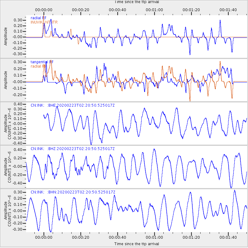
INK INUVIK, NT - Earthquake Result Viewer
*The percent match for this event was below the threshold and hence no stack was calculated.
| Earthquake location: |
Southern Molucca Sea |
| Earthquake latitude/longitude: |
-0.2/125.2 |
| Earthquake time(UTC): |
2020/02/23 (054) 02:08:04 GMT |
| Earthquake Depth: |
24 km |
| Earthquake Magnitude: |
5.3 Mww |
| Earthquake Catalog/Contributor: |
NEIC PDE/us |
|
| Network: |
CN Canadian National Seismograph Network |
| Station: |
INK INUVIK, NT |
| Lat/Lon: |
68.31 N/133.53 W |
| Elevation: |
44 m |
|
| Distance: |
94.4 deg |
| Az: |
21.448 deg |
| Baz: |
280.422 deg |
| Ray Param: |
$rayparam |
*The percent match for this event was below the threshold and hence was not used in the summary stack. |
|
| Radial Match: |
44.427586 % |
| Radial Bump: |
400 |
| Transverse Match: |
51.443336 % |
| Transverse Bump: |
400 |
| SOD ConfigId: |
20883691 |
| Insert Time: |
2020-04-06 22:37:32.192 +0000 |
| GWidth: |
2.5 |
| Max Bumps: |
400 |
| Tol: |
0.001 |
|
Signal To Noise
| Channel | StoN | STA | LTA |
| CN:INK: :BHZ:20200223T02:20:50.525017Z | 0.99643564 | 2.0721903E-7 | 2.0796027E-7 |
| CN:INK: :BHN:20200223T02:20:50.525017Z | 0.95365685 | 2.018212E-7 | 2.1162874E-7 |
| CN:INK: :BHE:20200223T02:20:50.525017Z | 1.8953521 | 2.6644742E-7 | 1.4057937E-7 |
| Arrivals |
| Ps | |
| PpPs | |
| PsPs/PpSs | |


