You are here: Home > Network List > TA - USArray Transportable Network (new EarthScope stations) Stations List
> Station C16K Lisburne Hills, AK, USA > Earthquake Result Viewer
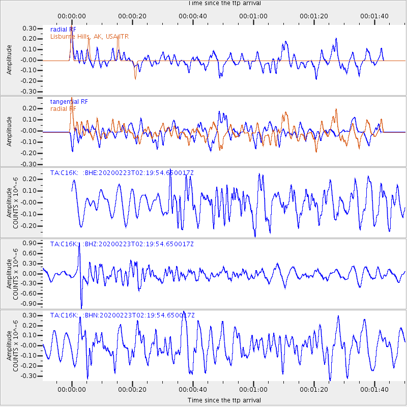
C16K Lisburne Hills, AK, USA - Earthquake Result Viewer
*The percent match for this event was below the threshold and hence no stack was calculated.
| Earthquake location: |
Southern Molucca Sea |
| Earthquake latitude/longitude: |
-0.2/125.2 |
| Earthquake time(UTC): |
2020/02/23 (054) 02:08:04 GMT |
| Earthquake Depth: |
24 km |
| Earthquake Magnitude: |
5.3 Mww |
| Earthquake Catalog/Contributor: |
NEIC PDE/us |
|
| Network: |
TA USArray Transportable Network (new EarthScope stations) |
| Station: |
C16K Lisburne Hills, AK, USA |
| Lat/Lon: |
68.27 N/165.34 W |
| Elevation: |
102 m |
|
| Distance: |
82.7 deg |
| Az: |
20.58 deg |
| Baz: |
250.761 deg |
| Ray Param: |
$rayparam |
*The percent match for this event was below the threshold and hence was not used in the summary stack. |
|
| Radial Match: |
62.789112 % |
| Radial Bump: |
400 |
| Transverse Match: |
48.558132 % |
| Transverse Bump: |
400 |
| SOD ConfigId: |
20883691 |
| Insert Time: |
2020-04-06 23:23:17.581 +0000 |
| GWidth: |
2.5 |
| Max Bumps: |
400 |
| Tol: |
0.001 |
|
Signal To Noise
| Channel | StoN | STA | LTA |
| TA:C16K: :BHZ:20200223T02:19:54.650017Z | 2.352665 | 3.823848E-7 | 1.6253261E-7 |
| TA:C16K: :BHN:20200223T02:19:54.650017Z | 2.0316014 | 1.3778465E-7 | 6.7820714E-8 |
| TA:C16K: :BHE:20200223T02:19:54.650017Z | 1.0344999 | 1.0193457E-7 | 9.8535125E-8 |
| Arrivals |
| Ps | |
| PpPs | |
| PsPs/PpSs | |


