You are here: Home > Network List > G - GEOSCOPE Stations List
> Station MPG Montagne des Peres, French Guyana > Earthquake Result Viewer
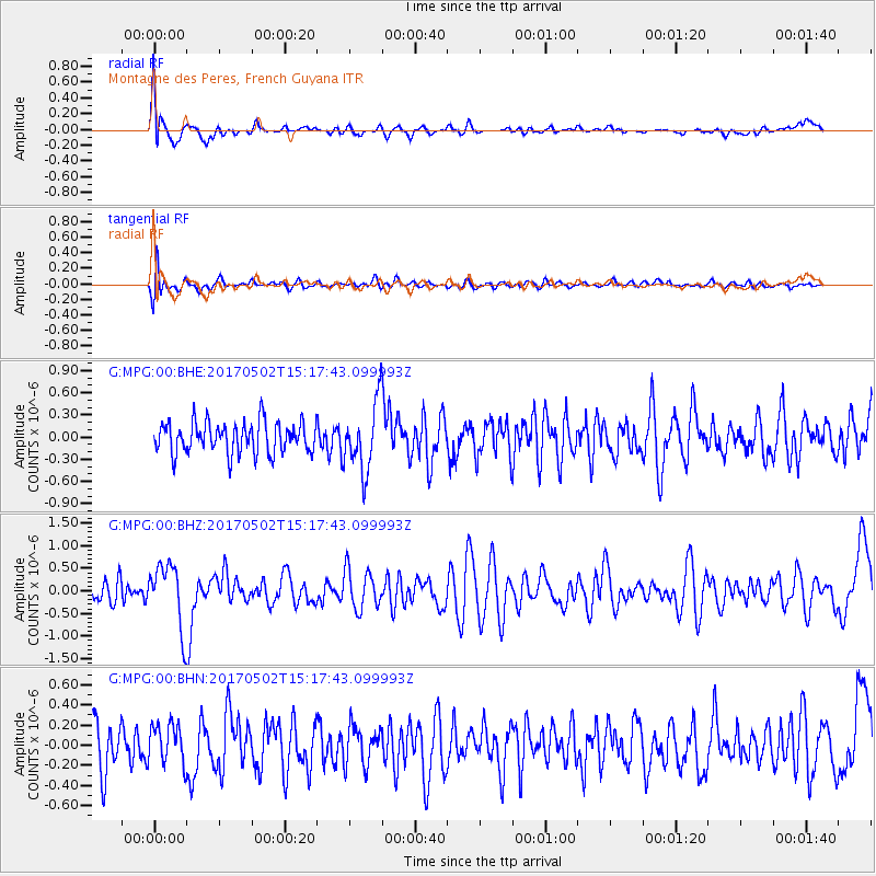
MPG Montagne des Peres, French Guyana - Earthquake Result Viewer
*The percent match for this event was below the threshold and hence no stack was calculated.
| Earthquake location: |
Ascension Island Region |
| Earthquake latitude/longitude: |
-11.7/-13.9 |
| Earthquake time(UTC): |
2017/05/02 (122) 15:10:22 GMT |
| Earthquake Depth: |
10 km |
| Earthquake Magnitude: |
5.6 mb |
| Earthquake Catalog/Contributor: |
NEIC PDE/us |
|
| Network: |
G GEOSCOPE |
| Station: |
MPG Montagne des Peres, French Guyana |
| Lat/Lon: |
5.11 N/52.64 W |
| Elevation: |
147 m |
|
| Distance: |
42.0 deg |
| Az: |
291.344 deg |
| Baz: |
113.678 deg |
| Ray Param: |
$rayparam |
*The percent match for this event was below the threshold and hence was not used in the summary stack. |
|
| Radial Match: |
74.04319 % |
| Radial Bump: |
400 |
| Transverse Match: |
61.30094 % |
| Transverse Bump: |
400 |
| SOD ConfigId: |
2028011 |
| Insert Time: |
2017-05-16 15:14:23.532 +0000 |
| GWidth: |
2.5 |
| Max Bumps: |
400 |
| Tol: |
0.001 |
|
Signal To Noise
| Channel | StoN | STA | LTA |
| G:MPG:00:BHZ:20170502T15:17:43.099993Z | 2.7296567 | 7.2012523E-7 | 2.638153E-7 |
| G:MPG:00:BHN:20170502T15:17:43.099993Z | 0.9683045 | 1.9873697E-7 | 2.0524222E-7 |
| G:MPG:00:BHE:20170502T15:17:43.099993Z | 2.1673515 | 4.5678948E-7 | 2.1075928E-7 |
| Arrivals |
| Ps | |
| PpPs | |
| PsPs/PpSs | |


