You are here: Home > Network List > TS - TERRAscope (Southern California Seismic Network) Stations List
> Station PFO Pinon Flat, California, USA > Earthquake Result Viewer
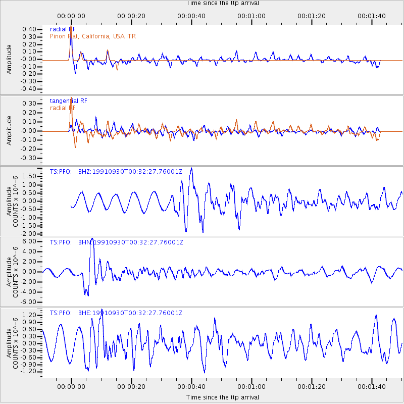
PFO Pinon Flat, California, USA - Earthquake Result Viewer
*The percent match for this event was below the threshold and hence no stack was calculated.
| Earthquake location: |
Fiji Islands Region |
| Earthquake latitude/longitude: |
-21.0/-178.6 |
| Earthquake time(UTC): |
1991/09/30 (273) 00:21:47 GMT |
| Earthquake Depth: |
580 km |
| Earthquake Magnitude: |
6.0 MB, 6.5 UNKNOWN |
| Earthquake Catalog/Contributor: |
WHDF/NEIC |
|
| Network: |
TS TERRAscope (Southern California Seismic Network) |
| Station: |
PFO Pinon Flat, California, USA |
| Lat/Lon: |
33.61 N/116.46 W |
| Elevation: |
1280 m |
|
| Distance: |
80.3 deg |
| Az: |
48.467 deg |
| Baz: |
236.959 deg |
| Ray Param: |
$rayparam |
*The percent match for this event was below the threshold and hence was not used in the summary stack. |
|
| Radial Match: |
58.447227 % |
| Radial Bump: |
372 |
| Transverse Match: |
49.506836 % |
| Transverse Bump: |
382 |
| SOD ConfigId: |
4480 |
| Insert Time: |
2010-02-26 14:43:40.758 +0000 |
| GWidth: |
2.5 |
| Max Bumps: |
400 |
| Tol: |
0.001 |
|
Signal To Noise
| Channel | StoN | STA | LTA |
| TS:PFO: :BHN:19910930T00:32:27.76001Z | 3.6463523 | 1.4965539E-6 | 4.104249E-7 |
| TS:PFO: :BHE:19910930T00:32:27.76001Z | 1.5950769 | 5.917858E-7 | 3.7100767E-7 |
| TS:PFO: :BHZ:19910930T00:32:27.76001Z | 0.90383255 | 3.6596163E-7 | 4.0489982E-7 |
| Arrivals |
| Ps | |
| PpPs | |
| PsPs/PpSs | |


