You are here: Home > Network List > TS - TERRAscope (Southern California Seismic Network) Stations List
> Station PFO Pinon Flat, California, USA > Earthquake Result Viewer
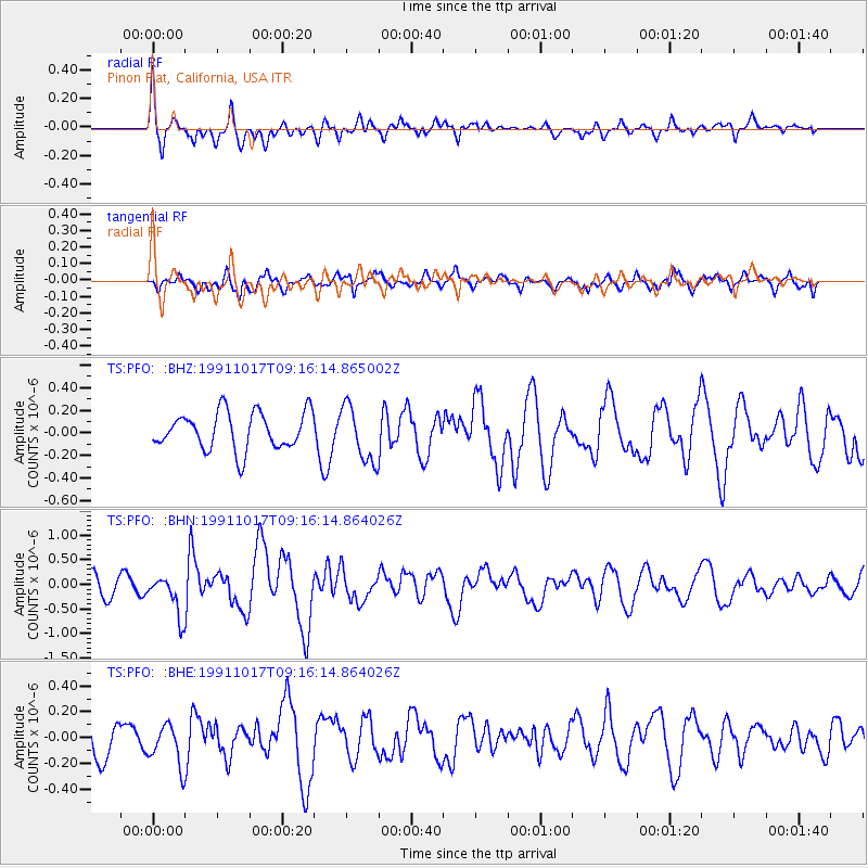
PFO Pinon Flat, California, USA - Earthquake Result Viewer
*The percent match for this event was below the threshold and hence no stack was calculated.
| Earthquake location: |
Tonga Islands |
| Earthquake latitude/longitude: |
-15.2/-173.7 |
| Earthquake time(UTC): |
1991/10/17 (290) 09:05:19 GMT |
| Earthquake Depth: |
33 km |
| Earthquake Magnitude: |
5.7 MB, 6.0 MS |
| Earthquake Catalog/Contributor: |
WHDF/NEIC |
|
| Network: |
TS TERRAscope (Southern California Seismic Network) |
| Station: |
PFO Pinon Flat, California, USA |
| Lat/Lon: |
33.61 N/116.46 W |
| Elevation: |
1280 m |
|
| Distance: |
73.0 deg |
| Az: |
47.225 deg |
| Baz: |
238.12 deg |
| Ray Param: |
$rayparam |
*The percent match for this event was below the threshold and hence was not used in the summary stack. |
|
| Radial Match: |
59.44352 % |
| Radial Bump: |
400 |
| Transverse Match: |
58.162094 % |
| Transverse Bump: |
400 |
| SOD ConfigId: |
4480 |
| Insert Time: |
2010-02-26 14:43:41.191 +0000 |
| GWidth: |
2.5 |
| Max Bumps: |
400 |
| Tol: |
0.001 |
|
Signal To Noise
| Channel | StoN | STA | LTA |
| TS:PFO: :BHN:19911017T09:16:14.864026Z | 2.1788003 | 4.18031E-7 | 1.9186291E-7 |
| TS:PFO: :BHE:19911017T09:16:14.864026Z | 1.0680219 | 1.6262968E-7 | 1.5227185E-7 |
| TS:PFO: :BHZ:19911017T09:16:14.865002Z | 1.5176668 | 2.4936634E-7 | 1.6430901E-7 |
| Arrivals |
| Ps | |
| PpPs | |
| PsPs/PpSs | |


