You are here: Home > Network List > TS - TERRAscope (Southern California Seismic Network) Stations List
> Station PFO Pinon Flat, California, USA > Earthquake Result Viewer
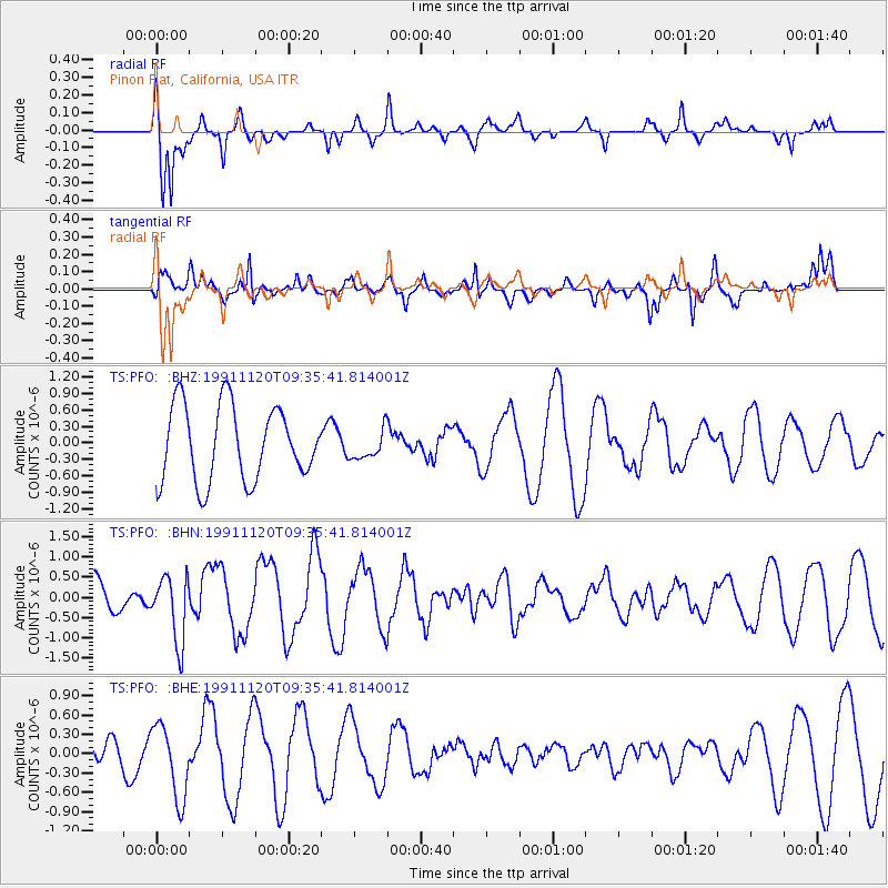
PFO Pinon Flat, California, USA - Earthquake Result Viewer
*The percent match for this event was below the threshold and hence no stack was calculated.
| Earthquake location: |
Off E. Coast Of N. Island, N.Z. |
| Earthquake latitude/longitude: |
-36.6/178.1 |
| Earthquake time(UTC): |
1991/11/20 (324) 09:23:12 GMT |
| Earthquake Depth: |
102 km |
| Earthquake Magnitude: |
6.1 MB |
| Earthquake Catalog/Contributor: |
WHDF/NEIC |
|
| Network: |
TS TERRAscope (Southern California Seismic Network) |
| Station: |
PFO Pinon Flat, California, USA |
| Lat/Lon: |
33.61 N/116.46 W |
| Elevation: |
1280 m |
|
| Distance: |
92.7 deg |
| Az: |
49.457 deg |
| Baz: |
227.144 deg |
| Ray Param: |
$rayparam |
*The percent match for this event was below the threshold and hence was not used in the summary stack. |
|
| Radial Match: |
83.00699 % |
| Radial Bump: |
287 |
| Transverse Match: |
70.247116 % |
| Transverse Bump: |
400 |
| SOD ConfigId: |
4480 |
| Insert Time: |
2010-02-26 14:43:42.377 +0000 |
| GWidth: |
2.5 |
| Max Bumps: |
400 |
| Tol: |
0.001 |
|
Signal To Noise
| Channel | StoN | STA | LTA |
| TS:PFO: :BHN:19911120T09:35:41.814001Z | 1.990263 | 8.134147E-7 | 4.086971E-7 |
| TS:PFO: :BHE:19911120T09:35:41.814001Z | 1.2634605 | 5.685547E-7 | 4.49998E-7 |
| TS:PFO: :BHZ:19911120T09:35:41.814001Z | 0.39025757 | 2.6551976E-7 | 6.803706E-7 |
| Arrivals |
| Ps | |
| PpPs | |
| PsPs/PpSs | |


