You are here: Home > Network List > MX - Mexican National Seismic Network Stations List
> Station MOIG Morelia, Mich, MX > Earthquake Result Viewer
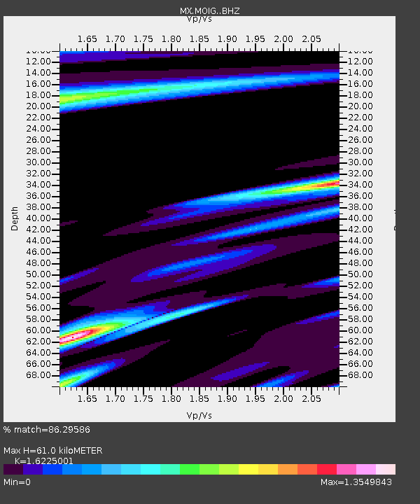
MOIG Morelia, Mich, MX - Earthquake Result Viewer
| Earthquake location: |
Puerto Rico Region |
| Earthquake latitude/longitude: |
17.9/-66.8 |
| Earthquake time(UTC): |
2020/01/07 (007) 08:24:26 GMT |
| Earthquake Depth: |
10 km |
| Earthquake Magnitude: |
6.4 mww |
| Earthquake Catalog/Contributor: |
NEIC PDE/us |
|
| Network: |
MX Mexican National Seismic Network |
| Station: |
MOIG Morelia, Mich, MX |
| Lat/Lon: |
19.65 N/101.23 W |
| Elevation: |
2000 m |
|
| Distance: |
32.6 deg |
| Az: |
278.592 deg |
| Baz: |
87.27 deg |
| Ray Param: |
0.07859471 |
| Estimated Moho Depth: |
61.0 km |
| Estimated Crust Vp/Vs: |
1.62 |
| Assumed Crust Vp: |
6.566 km/s |
| Estimated Crust Vs: |
4.047 km/s |
| Estimated Crust Poisson's Ratio: |
0.19 |
|
| Radial Match: |
86.29586 % |
| Radial Bump: |
400 |
| Transverse Match: |
58.31575 % |
| Transverse Bump: |
400 |
| SOD ConfigId: |
20906531 |
| Insert Time: |
2020-04-07 21:41:15.364 +0000 |
| GWidth: |
2.5 |
| Max Bumps: |
400 |
| Tol: |
0.001 |
|

Signal To Noise
| Channel | StoN | STA | LTA |
| MX:MOIG: :BHZ:20200107T08:30:26.244002Z | 3.3075728 | 9.0463004E-7 | 2.7350268E-7 |
| MX:MOIG: :BHN:20200107T08:30:26.244002Z | 1.4259902 | 4.3470936E-7 | 3.048474E-7 |
| MX:MOIG: :BHE:20200107T08:30:26.244002Z | 2.7154899 | 5.8517185E-7 | 2.1549401E-7 |
| Arrivals |
| Ps | 6.3 SECOND |
| PpPs | 22 SECOND |
| PsPs/PpSs | 29 SECOND |


