You are here: Home > Network List > TS - TERRAscope (Southern California Seismic Network) Stations List
> Station PFO Pinon Flat, California, USA > Earthquake Result Viewer
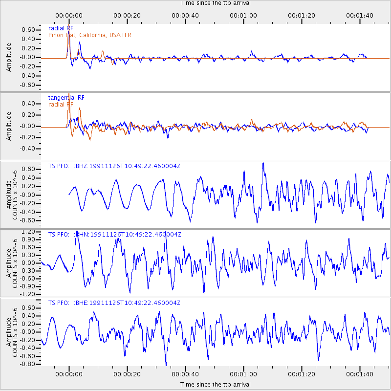
PFO Pinon Flat, California, USA - Earthquake Result Viewer
*The percent match for this event was below the threshold and hence no stack was calculated.
| Earthquake location: |
Andreanof Islands, Aleutian Is. |
| Earthquake latitude/longitude: |
51.8/-176.1 |
| Earthquake time(UTC): |
1991/11/26 (330) 10:41:35 GMT |
| Earthquake Depth: |
69 km |
| Earthquake Magnitude: |
5.8 MB |
| Earthquake Catalog/Contributor: |
WHDF/NEIC |
|
| Network: |
TS TERRAscope (Southern California Seismic Network) |
| Station: |
PFO Pinon Flat, California, USA |
| Lat/Lon: |
33.61 N/116.46 W |
| Elevation: |
1280 m |
|
| Distance: |
46.1 deg |
| Az: |
89.091 deg |
| Baz: |
311.964 deg |
| Ray Param: |
$rayparam |
*The percent match for this event was below the threshold and hence was not used in the summary stack. |
|
| Radial Match: |
68.91103 % |
| Radial Bump: |
400 |
| Transverse Match: |
68.37704 % |
| Transverse Bump: |
400 |
| SOD ConfigId: |
4480 |
| Insert Time: |
2010-02-26 14:43:43.506 +0000 |
| GWidth: |
2.5 |
| Max Bumps: |
400 |
| Tol: |
0.001 |
|
Signal To Noise
| Channel | StoN | STA | LTA |
| TS:PFO: :BHN:19911126T10:49:22.460004Z | 5.336833 | 5.7684156E-7 | 1.08086866E-7 |
| TS:PFO: :BHE:19911126T10:49:22.460004Z | 1.0518978 | 1.62794E-7 | 1.5476219E-7 |
| TS:PFO: :BHZ:19911126T10:49:22.460004Z | 1.474479 | 2.833659E-7 | 1.9218037E-7 |
| Arrivals |
| Ps | |
| PpPs | |
| PsPs/PpSs | |


