You are here: Home > Network List > O2 - Oklahoma Consolidated Temporary Seismic Networks Stations List
> Station SC18 Garber, Oklahoma, USA > Earthquake Result Viewer
SC18 Garber, Oklahoma, USA - Earthquake Result Viewer
| Earthquake location: |
Andreanof Islands, Aleutian Is. |
| Earthquake latitude/longitude: |
51.9/-177.8 |
| Earthquake time(UTC): |
2020/01/23 (023) 05:53:03 GMT |
| Earthquake Depth: |
10 km |
| Earthquake Magnitude: |
6.2 Mw |
| Earthquake Catalog/Contributor: |
NEIC PDE/us |
|
| Network: |
O2 Oklahoma Consolidated Temporary Seismic Networks |
| Station: |
SC18 Garber, Oklahoma, USA |
| Lat/Lon: |
36.50 N/97.55 W |
| Elevation: |
1051 m |
|
| Distance: |
56.7 deg |
| Az: |
71.876 deg |
| Baz: |
313.07 deg |
| Ray Param: |
0.06398698 |
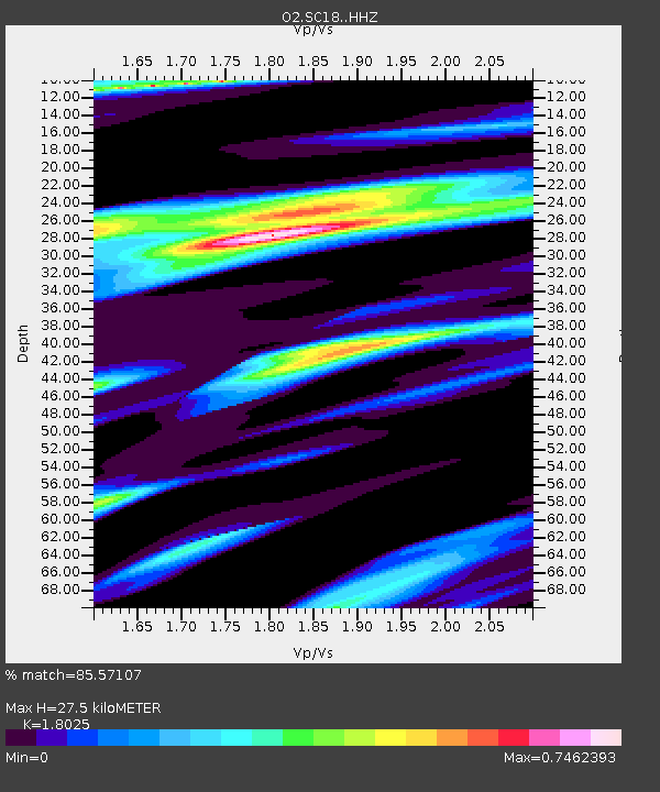
| Estimated Moho Depth: |
27.5 km |
| Estimated Crust Vp/Vs: |
1.80 |
| Assumed Crust Vp: |
6.483 km/s |
| Estimated Crust Vs: |
3.596 km/s |
| Estimated Crust Poisson's Ratio: |
0.28 |
|
| Radial Match: |
85.57107 % |
| Radial Bump: |
379 |
| Transverse Match: |
66.44939 % |
| Transverse Bump: |
400 |
| SOD ConfigId: |
20906531 |
| Insert Time: |
2020-04-08 01:03:16.315 +0000 |
| GWidth: |
2.5 |
| Max Bumps: |
400 |
| Tol: |
0.001 |
|

Signal To Noise
| Channel | StoN | STA | LTA |
| O2:SC18: :HHZ:20200123T06:02:14.979986Z | 9.650991 | 2.2621684E-6 | 2.343975E-7 |
| O2:SC18: :HHN:20200123T06:02:14.979986Z | 4.030841 | 8.074268E-7 | 2.0031224E-7 |
| O2:SC18: :HHE:20200123T06:02:14.979986Z | 3.938868 | 1.0266663E-6 | 2.6065007E-7 |
| Arrivals |
| Ps | 3.6 SECOND |
| PpPs | 11 SECOND |
| PsPs/PpSs | 15 SECOND |


