You are here: Home > Network List > US - United States National Seismic Network Stations List
> Station HLID Hailey, Idaho, USA > Earthquake Result Viewer
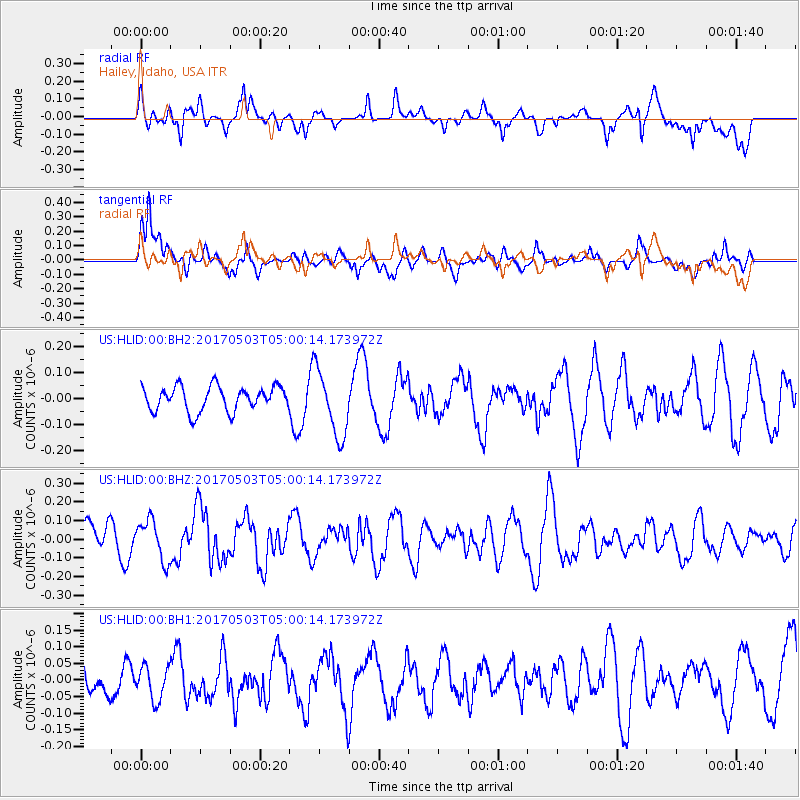
HLID Hailey, Idaho, USA - Earthquake Result Viewer
*The percent match for this event was below the threshold and hence no stack was calculated.
| Earthquake location: |
Tajikistan |
| Earthquake latitude/longitude: |
39.5/71.4 |
| Earthquake time(UTC): |
2017/05/03 (123) 04:47:13 GMT |
| Earthquake Depth: |
10 km |
| Earthquake Magnitude: |
5.9 Mww |
| Earthquake Catalog/Contributor: |
NEIC PDE/us |
|
| Network: |
US United States National Seismic Network |
| Station: |
HLID Hailey, Idaho, USA |
| Lat/Lon: |
43.56 N/114.41 W |
| Elevation: |
1772 m |
|
| Distance: |
97.1 deg |
| Az: |
4.258 deg |
| Baz: |
355.468 deg |
| Ray Param: |
$rayparam |
*The percent match for this event was below the threshold and hence was not used in the summary stack. |
|
| Radial Match: |
60.91336 % |
| Radial Bump: |
400 |
| Transverse Match: |
55.205147 % |
| Transverse Bump: |
400 |
| SOD ConfigId: |
2028011 |
| Insert Time: |
2017-05-17 04:53:06.529 +0000 |
| GWidth: |
2.5 |
| Max Bumps: |
400 |
| Tol: |
0.001 |
|
Signal To Noise
| Channel | StoN | STA | LTA |
| US:HLID:00:BHZ:20170503T05:00:14.173972Z | 1.0160438 | 1.07357586E-7 | 1.0566236E-7 |
| US:HLID:00:BH1:20170503T05:00:14.173972Z | 0.5611258 | 4.997267E-8 | 8.905787E-8 |
| US:HLID:00:BH2:20170503T05:00:14.173972Z | 2.6901474 | 1.263146E-7 | 4.6954526E-8 |
| Arrivals |
| Ps | |
| PpPs | |
| PsPs/PpSs | |


