You are here: Home > Network List > CI - Caltech Regional Seismic Network Stations List
> Station MPP McPhearson Peak > Earthquake Result Viewer
MPP McPhearson Peak - Earthquake Result Viewer
*The percent match for this event was below the threshold and hence no stack was calculated.
| Earthquake location: |
Andreanof Islands, Aleutian Is. |
| Earthquake latitude/longitude: |
50.9/-179.9 |
| Earthquake time(UTC): |
2020/01/26 (026) 06:31:55 GMT |
| Earthquake Depth: |
1.0 km |
| Earthquake Magnitude: |
5.6 Mi |
| Earthquake Catalog/Contributor: |
NEIC PDE/at |
|
| Network: |
CI Caltech Regional Seismic Network |
| Station: |
MPP McPhearson Peak |
| Lat/Lon: |
34.89 N/119.81 W |
| Elevation: |
1739 m |
|
| Distance: |
45.5 deg |
| Az: |
86.568 deg |
| Baz: |
309.78 deg |
| Ray Param: |
$rayparam |
*The percent match for this event was below the threshold and hence was not used in the summary stack. |
|
| Radial Match: |
58.76614 % |
| Radial Bump: |
400 |
| Transverse Match: |
68.67828 % |
| Transverse Bump: |
400 |
| SOD ConfigId: |
20906531 |
| Insert Time: |
2020-04-08 02:14:51.687 +0000 |
| GWidth: |
2.5 |
| Max Bumps: |
400 |
| Tol: |
0.001 |
|
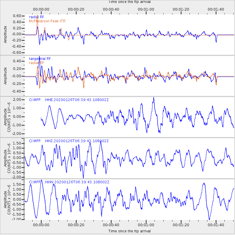
Signal To Noise
| Channel | StoN | STA | LTA |
| CI:MPP: :HHZ:20200126T06:39:43.108002Z | 1.6413628 | 8.104335E-7 | 4.9375643E-7 |
| CI:MPP: :HHN:20200126T06:39:43.108002Z | 2.2755368 | 1.2459456E-6 | 5.4753923E-7 |
| CI:MPP: :HHE:20200126T06:39:43.108002Z | 0.758775 | 4.396151E-7 | 5.793748E-7 |
| Arrivals |
| Ps | |
| PpPs | |
| PsPs/PpSs | |


