You are here: Home > Network List > 1E - GSC-BCOGC Induced Seismicity Study Stations List
> Station MONT2 Z > Earthquake Result Viewer
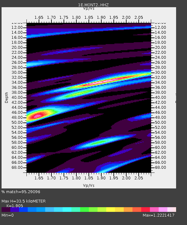
MONT2 Z - Earthquake Result Viewer
| Earthquake location: |
Cuba Region |
| Earthquake latitude/longitude: |
19.3/-78.8 |
| Earthquake time(UTC): |
2020/01/28 (028) 19:10:23 GMT |
| Earthquake Depth: |
10 km |
| Earthquake Magnitude: |
7.3 Mi |
| Earthquake Catalog/Contributor: |
NEIC PDE/pt |
|
| Network: |
1E GSC-BCOGC Induced Seismicity Study |
| Station: |
MONT2 Z |
| Lat/Lon: |
56.02 N/120.05 W |
| Elevation: |
642 m |
|
| Distance: |
47.9 deg |
| Az: |
330.063 deg |
| Baz: |
122.925 deg |
| Ray Param: |
0.06973668 |
| Estimated Moho Depth: |
33.5 km |
| Estimated Crust Vp/Vs: |
1.90 |
| Assumed Crust Vp: |
6.291 km/s |
| Estimated Crust Vs: |
3.302 km/s |
| Estimated Crust Poisson's Ratio: |
0.31 |
|
| Radial Match: |
95.29096 % |
| Radial Bump: |
378 |
| Transverse Match: |
86.7063 % |
| Transverse Bump: |
400 |
| SOD ConfigId: |
20906531 |
| Insert Time: |
2020-04-08 03:07:01.470 +0000 |
| GWidth: |
2.5 |
| Max Bumps: |
400 |
| Tol: |
0.001 |
|

Signal To Noise
| Channel | StoN | STA | LTA |
| 1E:MONT2: :HHZ:20200128T19:18:30.709991Z | 1.0503095 | 4.7773773E-7 | 4.5485424E-7 |
| 1E:MONT2: :HHN:20200128T19:18:30.709991Z | 1.5100669 | 4.809966E-7 | 3.185267E-7 |
| 1E:MONT2: :HHE:20200128T19:18:30.709991Z | 0.5516338 | 3.462468E-7 | 6.276751E-7 |
| Arrivals |
| Ps | 5.1 SECOND |
| PpPs | 15 SECOND |
| PsPs/PpSs | 20 SECOND |


