You are here: Home > Network List > UU - University of Utah Regional Network Stations List
> Station FOR3 Blundell North, UT, USA > Earthquake Result Viewer
FOR3 Blundell North, UT, USA - Earthquake Result Viewer
| Earthquake location: |
Cuba Region |
| Earthquake latitude/longitude: |
19.3/-78.8 |
| Earthquake time(UTC): |
2020/01/28 (028) 19:10:23 GMT |
| Earthquake Depth: |
10 km |
| Earthquake Magnitude: |
7.3 Mi |
| Earthquake Catalog/Contributor: |
NEIC PDE/pt |
|
| Network: |
UU University of Utah Regional Network |
| Station: |
FOR3 Blundell North, UT, USA |
| Lat/Lon: |
38.51 N/112.88 W |
| Elevation: |
1699 m |
|
| Distance: |
35.2 deg |
| Az: |
310.248 deg |
| Baz: |
113.244 deg |
| Ray Param: |
0.07737792 |
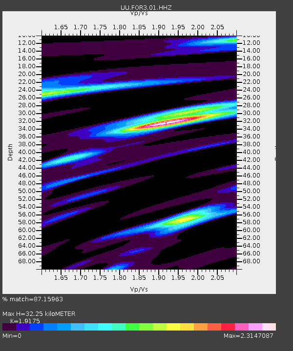
| Estimated Moho Depth: |
32.25 km |
| Estimated Crust Vp/Vs: |
1.92 |
| Assumed Crust Vp: |
6.276 km/s |
| Estimated Crust Vs: |
3.273 km/s |
| Estimated Crust Poisson's Ratio: |
0.31 |
|
| Radial Match: |
87.15963 % |
| Radial Bump: |
360 |
| Transverse Match: |
78.513596 % |
| Transverse Bump: |
400 |
| SOD ConfigId: |
20906531 |
| Insert Time: |
2020-04-08 03:16:03.772 +0000 |
| GWidth: |
2.5 |
| Max Bumps: |
400 |
| Tol: |
0.001 |
|

Signal To Noise
| Channel | StoN | STA | LTA |
| UU:FOR3:01:HHZ:20200128T19:16:46.945007Z | 2.5150485 | 2.8582553E-8 | 1.1364613E-8 |
| UU:FOR3:01:HHN:20200128T19:16:46.945007Z | 1.0296146 | 1.4141393E-8 | 1.3734646E-8 |
| UU:FOR3:01:HHE:20200128T19:16:46.945007Z | 1.7254018 | 2.3109694E-8 | 1.3393804E-8 |
| Arrivals |
| Ps | 5.0 SECOND |
| PpPs | 14 SECOND |
| PsPs/PpSs | 19 SECOND |


