You are here: Home > Network List > AV - Alaska Volcano Observatory Stations List
> Station AMKA Regional Station, Amchitka Island, Alaska > Earthquake Result Viewer
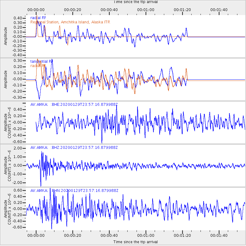
AMKA Regional Station, Amchitka Island, Alaska - Earthquake Result Viewer
*The percent match for this event was below the threshold and hence no stack was calculated.
| Earthquake location: |
Northern Molucca Sea |
| Earthquake latitude/longitude: |
0.7/126.3 |
| Earthquake time(UTC): |
2020/01/29 (029) 23:46:54 GMT |
| Earthquake Depth: |
15 km |
| Earthquake Magnitude: |
5.7 mww |
| Earthquake Catalog/Contributor: |
NEIC PDE/us |
|
| Network: |
AV Alaska Volcano Observatory |
| Station: |
AMKA Regional Station, Amchitka Island, Alaska |
| Lat/Lon: |
51.38 N/179.30 E |
| Elevation: |
116 m |
|
| Distance: |
67.2 deg |
| Az: |
32.873 deg |
| Baz: |
239.995 deg |
| Ray Param: |
$rayparam |
*The percent match for this event was below the threshold and hence was not used in the summary stack. |
|
| Radial Match: |
53.289715 % |
| Radial Bump: |
400 |
| Transverse Match: |
59.818443 % |
| Transverse Bump: |
400 |
| SOD ConfigId: |
20906531 |
| Insert Time: |
2020-04-08 03:34:00.323 +0000 |
| GWidth: |
2.5 |
| Max Bumps: |
400 |
| Tol: |
0.001 |
|
Signal To Noise
| Channel | StoN | STA | LTA |
| AV:AMKA: :BHZ:20200129T23:57:16.879988Z | 7.033214 | 7.4457205E-7 | 1.0586512E-7 |
| AV:AMKA: :BHN:20200129T23:57:16.879988Z | 1.497919 | 1.8296446E-7 | 1.2214576E-7 |
| AV:AMKA: :BHE:20200129T23:57:16.879988Z | 0.98366493 | 1.281885E-7 | 1.3031725E-7 |
| Arrivals |
| Ps | |
| PpPs | |
| PsPs/PpSs | |


