You are here: Home > Network List > CN - Canadian National Seismograph Network Stations List
> Station INK INUVIK, NT > Earthquake Result Viewer
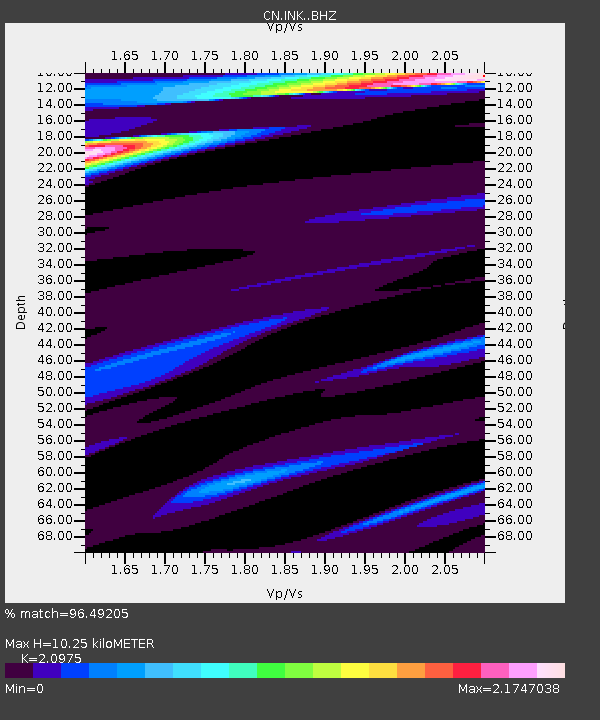
INK INUVIK, NT - Earthquake Result Viewer
| Earthquake location: |
Dodecanese Islands, Greece |
| Earthquake latitude/longitude: |
35.2/27.9 |
| Earthquake time(UTC): |
2020/01/30 (030) 01:28:06 GMT |
| Earthquake Depth: |
10 km |
| Earthquake Magnitude: |
5.6 mww |
| Earthquake Catalog/Contributor: |
NEIC PDE/us |
|
| Network: |
CN Canadian National Seismograph Network |
| Station: |
INK INUVIK, NT |
| Lat/Lon: |
68.31 N/133.53 W |
| Elevation: |
44 m |
|
| Distance: |
75.9 deg |
| Az: |
352.989 deg |
| Baz: |
15.598 deg |
| Ray Param: |
0.051376395 |
| Estimated Moho Depth: |
10.25 km |
| Estimated Crust Vp/Vs: |
2.10 |
| Assumed Crust Vp: |
6.171 km/s |
| Estimated Crust Vs: |
2.942 km/s |
| Estimated Crust Poisson's Ratio: |
0.35 |
|
| Radial Match: |
96.49205 % |
| Radial Bump: |
363 |
| Transverse Match: |
59.731575 % |
| Transverse Bump: |
400 |
| SOD ConfigId: |
20906531 |
| Insert Time: |
2020-04-08 03:42:04.469 +0000 |
| GWidth: |
2.5 |
| Max Bumps: |
400 |
| Tol: |
0.001 |
|

Signal To Noise
| Channel | StoN | STA | LTA |
| CN:INK: :BHZ:20200130T01:39:20.57503Z | 1.7763046 | 1.8948206E-6 | 1.0667205E-6 |
| CN:INK: :BHN:20200130T01:39:20.57503Z | 1.8487993 | 1.4126658E-6 | 7.6409907E-7 |
| CN:INK: :BHE:20200130T01:39:20.57503Z | 0.17800479 | 1.110299E-7 | 6.2374676E-7 |
| Arrivals |
| Ps | 1.9 SECOND |
| PpPs | 5.0 SECOND |
| PsPs/PpSs | 6.9 SECOND |


