You are here: Home > Network List > AV - Alaska Volcano Observatory Stations List
> Station AMKA Regional Station, Amchitka Island, Alaska > Earthquake Result Viewer
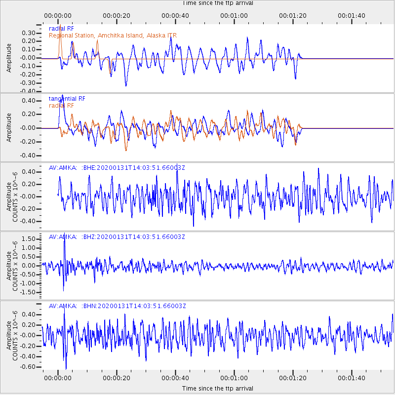
AMKA Regional Station, Amchitka Island, Alaska - Earthquake Result Viewer
*The percent match for this event was below the threshold and hence no stack was calculated.
| Earthquake location: |
South Of Fiji Islands |
| Earthquake latitude/longitude: |
-25.4/178.5 |
| Earthquake time(UTC): |
2020/01/31 (031) 13:53:30 GMT |
| Earthquake Depth: |
576 km |
| Earthquake Magnitude: |
5.7 mww |
| Earthquake Catalog/Contributor: |
NEIC PDE/us |
|
| Network: |
AV Alaska Volcano Observatory |
| Station: |
AMKA Regional Station, Amchitka Island, Alaska |
| Lat/Lon: |
51.38 N/179.30 E |
| Elevation: |
116 m |
|
| Distance: |
76.4 deg |
| Az: |
0.52 deg |
| Baz: |
180.751 deg |
| Ray Param: |
$rayparam |
*The percent match for this event was below the threshold and hence was not used in the summary stack. |
|
| Radial Match: |
59.350716 % |
| Radial Bump: |
400 |
| Transverse Match: |
51.45988 % |
| Transverse Bump: |
400 |
| SOD ConfigId: |
20906531 |
| Insert Time: |
2020-04-08 04:13:42.511 +0000 |
| GWidth: |
2.5 |
| Max Bumps: |
400 |
| Tol: |
0.001 |
|
Signal To Noise
| Channel | StoN | STA | LTA |
| AV:AMKA: :BHZ:20200131T14:03:51.66003Z | 3.6456091 | 4.930984E-7 | 1.3525816E-7 |
| AV:AMKA: :BHN:20200131T14:03:51.66003Z | 1.6086439 | 2.0474546E-7 | 1.272783E-7 |
| AV:AMKA: :BHE:20200131T14:03:51.66003Z | 1.0096675 | 1.4157584E-7 | 1.4022027E-7 |
| Arrivals |
| Ps | |
| PpPs | |
| PsPs/PpSs | |


