You are here: Home > Network List > TS - TERRAscope (Southern California Seismic Network) Stations List
> Station PFO Pinon Flat, California, USA > Earthquake Result Viewer
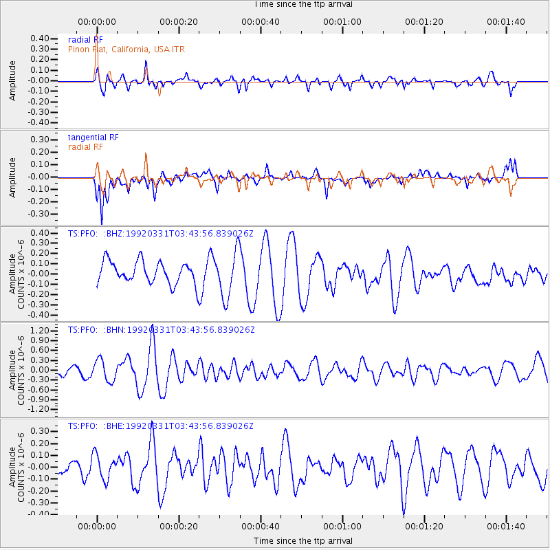
PFO Pinon Flat, California, USA - Earthquake Result Viewer
*The percent match for this event was below the threshold and hence no stack was calculated.
| Earthquake location: |
Southern East Pacific Rise |
| Earthquake latitude/longitude: |
-49.7/-113.8 |
| Earthquake time(UTC): |
1992/03/31 (091) 03:32:02 GMT |
| Earthquake Depth: |
10 km |
| Earthquake Magnitude: |
5.9 MS, 5.2 MB, 6.3 UNKNOWN |
| Earthquake Catalog/Contributor: |
WHDF/NEIC |
|
| Network: |
TS TERRAscope (Southern California Seismic Network) |
| Station: |
PFO Pinon Flat, California, USA |
| Lat/Lon: |
33.61 N/116.46 W |
| Elevation: |
1280 m |
|
| Distance: |
83.0 deg |
| Az: |
357.801 deg |
| Baz: |
178.29 deg |
| Ray Param: |
$rayparam |
*The percent match for this event was below the threshold and hence was not used in the summary stack. |
|
| Radial Match: |
79.503174 % |
| Radial Bump: |
400 |
| Transverse Match: |
73.74412 % |
| Transverse Bump: |
394 |
| SOD ConfigId: |
4480 |
| Insert Time: |
2010-02-26 14:43:47.942 +0000 |
| GWidth: |
2.5 |
| Max Bumps: |
400 |
| Tol: |
0.001 |
|
Signal To Noise
| Channel | StoN | STA | LTA |
| TS:PFO: :BHN:19920331T03:43:56.839026Z | 2.0710852 | 3.3136092E-7 | 1.5999387E-7 |
| TS:PFO: :BHE:19920331T03:43:56.839026Z | 0.7615189 | 1.0354974E-7 | 1.359779E-7 |
| TS:PFO: :BHZ:19920331T03:43:56.839026Z | 2.1895483 | 2.322887E-7 | 1.0608978E-7 |
| Arrivals |
| Ps | |
| PpPs | |
| PsPs/PpSs | |


