You are here: Home > Network List > CI - Caltech Regional Seismic Network Stations List
> Station SMM Simmler, CA, USA > Earthquake Result Viewer
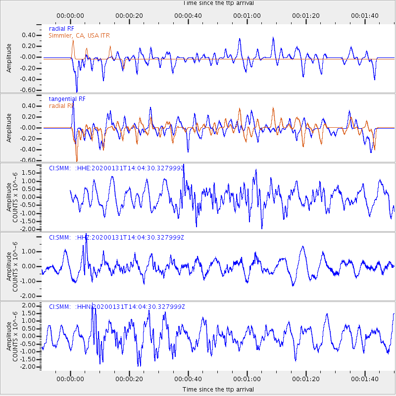
SMM Simmler, CA, USA - Earthquake Result Viewer
*The percent match for this event was below the threshold and hence no stack was calculated.
| Earthquake location: |
South Of Fiji Islands |
| Earthquake latitude/longitude: |
-25.4/178.5 |
| Earthquake time(UTC): |
2020/01/31 (031) 13:53:30 GMT |
| Earthquake Depth: |
576 km |
| Earthquake Magnitude: |
5.7 mww |
| Earthquake Catalog/Contributor: |
NEIC PDE/us |
|
| Network: |
CI Caltech Regional Seismic Network |
| Station: |
SMM Simmler, CA, USA |
| Lat/Lon: |
35.31 N/120.00 W |
| Elevation: |
599 m |
|
| Distance: |
83.8 deg |
| Az: |
46.302 deg |
| Baz: |
233.115 deg |
| Ray Param: |
$rayparam |
*The percent match for this event was below the threshold and hence was not used in the summary stack. |
|
| Radial Match: |
55.06985 % |
| Radial Bump: |
400 |
| Transverse Match: |
62.38539 % |
| Transverse Bump: |
400 |
| SOD ConfigId: |
20906531 |
| Insert Time: |
2020-04-08 04:17:19.960 +0000 |
| GWidth: |
2.5 |
| Max Bumps: |
400 |
| Tol: |
0.001 |
|
Signal To Noise
| Channel | StoN | STA | LTA |
| CI:SMM: :HHZ:20200131T14:04:30.327999Z | 1.8661622 | 7.038314E-7 | 3.7715446E-7 |
| CI:SMM: :HHN:20200131T14:04:30.327999Z | 0.77898574 | 4.5578884E-7 | 5.851055E-7 |
| CI:SMM: :HHE:20200131T14:04:30.327999Z | 1.1987444 | 6.8997156E-7 | 5.755786E-7 |
| Arrivals |
| Ps | |
| PpPs | |
| PsPs/PpSs | |


