You are here: Home > Network List > UU - University of Utah Regional Network Stations List
> Station CCUT Cedar City, UT, USA > Earthquake Result Viewer
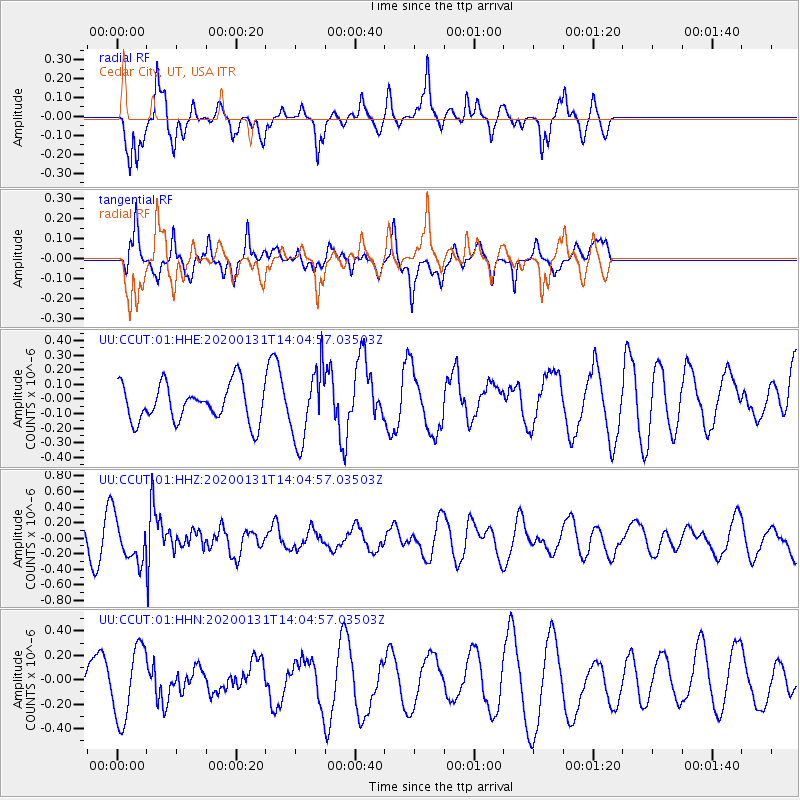
CCUT Cedar City, UT, USA - Earthquake Result Viewer
*The percent match for this event was below the threshold and hence no stack was calculated.
| Earthquake location: |
South Of Fiji Islands |
| Earthquake latitude/longitude: |
-25.4/178.5 |
| Earthquake time(UTC): |
2020/01/31 (031) 13:53:30 GMT |
| Earthquake Depth: |
576 km |
| Earthquake Magnitude: |
5.7 mww |
| Earthquake Catalog/Contributor: |
NEIC PDE/us |
|
| Network: |
UU University of Utah Regional Network |
| Station: |
CCUT Cedar City, UT, USA |
| Lat/Lon: |
37.55 N/113.36 W |
| Elevation: |
2127 m |
|
| Distance: |
89.5 deg |
| Az: |
47.534 deg |
| Baz: |
237.113 deg |
| Ray Param: |
$rayparam |
*The percent match for this event was below the threshold and hence was not used in the summary stack. |
|
| Radial Match: |
70.57278 % |
| Radial Bump: |
325 |
| Transverse Match: |
34.13339 % |
| Transverse Bump: |
350 |
| SOD ConfigId: |
20906531 |
| Insert Time: |
2020-04-08 04:21:59.965 +0000 |
| GWidth: |
2.5 |
| Max Bumps: |
400 |
| Tol: |
0.001 |
|
Signal To Noise
| Channel | StoN | STA | LTA |
| UU:CCUT:01:HHZ:20200131T14:04:57.03503Z | 2.0700788 | 2.790622E-7 | 1.3480752E-7 |
| UU:CCUT:01:HHN:20200131T14:04:57.03503Z | 1.4189323 | 2.9741886E-7 | 2.096075E-7 |
| UU:CCUT:01:HHE:20200131T14:04:57.03503Z | 1.6773635 | 2.141532E-7 | 1.2767251E-7 |
| Arrivals |
| Ps | |
| PpPs | |
| PsPs/PpSs | |


