You are here: Home > Network List > IU - Global Seismograph Network (GSN - IRIS/USGS) Stations List
> Station PMG Port Moresby, New Guinea > Earthquake Result Viewer
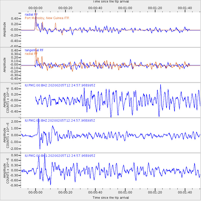
PMG Port Moresby, New Guinea - Earthquake Result Viewer
*The percent match for this event was below the threshold and hence no stack was calculated.
| Earthquake location: |
Macquarie Island Region |
| Earthquake latitude/longitude: |
-54.6/158.8 |
| Earthquake time(UTC): |
2020/02/05 (036) 12:17:05 GMT |
| Earthquake Depth: |
10 km |
| Earthquake Magnitude: |
5.6 Mww |
| Earthquake Catalog/Contributor: |
NEIC PDE/us |
|
| Network: |
IU Global Seismograph Network (GSN - IRIS/USGS) |
| Station: |
PMG Port Moresby, New Guinea |
| Lat/Lon: |
9.40 S/147.16 E |
| Elevation: |
90 m |
|
| Distance: |
46.0 deg |
| Az: |
343.968 deg |
| Baz: |
170.616 deg |
| Ray Param: |
$rayparam |
*The percent match for this event was below the threshold and hence was not used in the summary stack. |
|
| Radial Match: |
78.79149 % |
| Radial Bump: |
400 |
| Transverse Match: |
64.381035 % |
| Transverse Bump: |
400 |
| SOD ConfigId: |
20906531 |
| Insert Time: |
2020-04-08 04:35:44.023 +0000 |
| GWidth: |
2.5 |
| Max Bumps: |
400 |
| Tol: |
0.001 |
|
Signal To Noise
| Channel | StoN | STA | LTA |
| IU:PMG:00:BHZ:20200205T12:24:57.968995Z | 8.939374 | 9.318892E-7 | 1.0424546E-7 |
| IU:PMG:00:BH1:20200205T12:24:57.968995Z | 3.4326413 | 3.4088632E-7 | 9.930729E-8 |
| IU:PMG:00:BH2:20200205T12:24:57.968995Z | 2.0230076 | 1.7845899E-7 | 8.8214684E-8 |
| Arrivals |
| Ps | |
| PpPs | |
| PsPs/PpSs | |


