You are here: Home > Network List > AV - Alaska Volcano Observatory Stations List
> Station AMKA Regional Station, Amchitka Island, Alaska > Earthquake Result Viewer
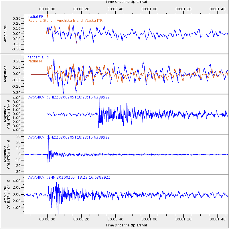
AMKA Regional Station, Amchitka Island, Alaska - Earthquake Result Viewer
*The percent match for this event was below the threshold and hence no stack was calculated.
| Earthquake location: |
Java, Indonesia |
| Earthquake latitude/longitude: |
-6.1/113.1 |
| Earthquake time(UTC): |
2020/02/05 (036) 18:12:37 GMT |
| Earthquake Depth: |
592 km |
| Earthquake Magnitude: |
6.2 mww |
| Earthquake Catalog/Contributor: |
NEIC PDE/us |
|
| Network: |
AV Alaska Volcano Observatory |
| Station: |
AMKA Regional Station, Amchitka Island, Alaska |
| Lat/Lon: |
51.38 N/179.30 E |
| Elevation: |
116 m |
|
| Distance: |
80.2 deg |
| Az: |
35.579 deg |
| Baz: |
247.397 deg |
| Ray Param: |
$rayparam |
*The percent match for this event was below the threshold and hence was not used in the summary stack. |
|
| Radial Match: |
70.691284 % |
| Radial Bump: |
400 |
| Transverse Match: |
71.95853 % |
| Transverse Bump: |
400 |
| SOD ConfigId: |
20906531 |
| Insert Time: |
2020-04-08 04:37:41.729 +0000 |
| GWidth: |
2.5 |
| Max Bumps: |
400 |
| Tol: |
0.001 |
|
Signal To Noise
| Channel | StoN | STA | LTA |
| AV:AMKA: :BHZ:20200205T18:23:16.638992Z | 28.578773 | 7.681114E-6 | 2.687699E-7 |
| AV:AMKA: :BHN:20200205T18:23:16.638992Z | 4.883242 | 1.2471817E-6 | 2.5540032E-7 |
| AV:AMKA: :BHE:20200205T18:23:16.638992Z | 7.2226586 | 1.392782E-6 | 1.9283507E-7 |
| Arrivals |
| Ps | |
| PpPs | |
| PsPs/PpSs | |


