You are here: Home > Network List > TS - TERRAscope (Southern California Seismic Network) Stations List
> Station PFO Pinon Flat, California, USA > Earthquake Result Viewer
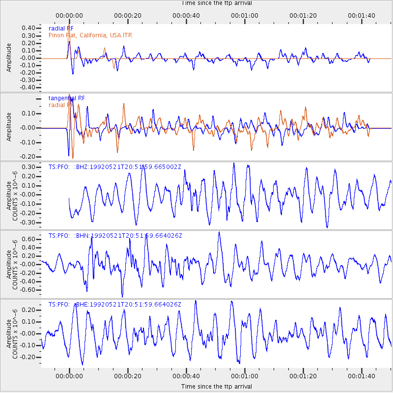
PFO Pinon Flat, California, USA - Earthquake Result Viewer
*The percent match for this event was below the threshold and hence no stack was calculated.
| Earthquake location: |
Southeast Of Honshu, Japan |
| Earthquake latitude/longitude: |
31.0/141.7 |
| Earthquake time(UTC): |
1992/05/21 (142) 20:40:13 GMT |
| Earthquake Depth: |
33 km |
| Earthquake Magnitude: |
5.5 MB, 5.7 MS |
| Earthquake Catalog/Contributor: |
WHDF/NEIC |
|
| Network: |
TS TERRAscope (Southern California Seismic Network) |
| Station: |
PFO Pinon Flat, California, USA |
| Lat/Lon: |
33.61 N/116.46 W |
| Elevation: |
1280 m |
|
| Distance: |
82.2 deg |
| Az: |
55.538 deg |
| Baz: |
301.973 deg |
| Ray Param: |
$rayparam |
*The percent match for this event was below the threshold and hence was not used in the summary stack. |
|
| Radial Match: |
54.11779 % |
| Radial Bump: |
400 |
| Transverse Match: |
53.82545 % |
| Transverse Bump: |
400 |
| SOD ConfigId: |
4480 |
| Insert Time: |
2010-02-26 14:43:50.400 +0000 |
| GWidth: |
2.5 |
| Max Bumps: |
400 |
| Tol: |
0.001 |
|
Signal To Noise
| Channel | StoN | STA | LTA |
| TS:PFO: :BHN:19920521T20:51:59.664026Z | 0.43562278 | 7.986541E-8 | 1.8333617E-7 |
| TS:PFO: :BHE:19920521T20:51:59.664026Z | 1.7100369 | 1.7304554E-7 | 1.0119404E-7 |
| TS:PFO: :BHZ:19920521T20:51:59.665002Z | 0.73004645 | 1.0037016E-7 | 1.3748462E-7 |
| Arrivals |
| Ps | |
| PpPs | |
| PsPs/PpSs | |


