You are here: Home > Network List > TA - USArray Transportable Network (new EarthScope stations) Stations List
> Station A22K Sinclair Lake, AK, USA > Earthquake Result Viewer
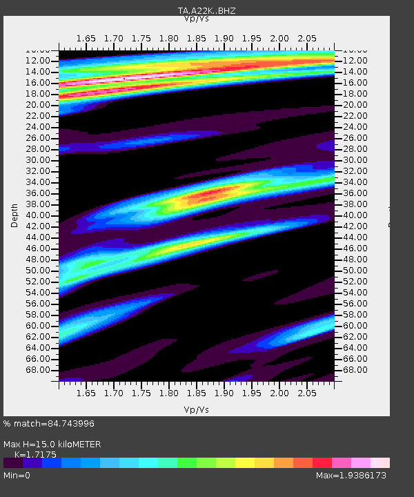
A22K Sinclair Lake, AK, USA - Earthquake Result Viewer
| Earthquake location: |
Off Coast Of Northern California |
| Earthquake latitude/longitude: |
40.4/-125.1 |
| Earthquake time(UTC): |
2020/03/09 (069) 02:59:08 GMT |
| Earthquake Depth: |
3.2 km |
| Earthquake Magnitude: |
5.8 Mw |
| Earthquake Catalog/Contributor: |
NEIC PDE/nc |
|
| Network: |
TA USArray Transportable Network (new EarthScope stations) |
| Station: |
A22K Sinclair Lake, AK, USA |
| Lat/Lon: |
71.00 N/154.97 W |
| Elevation: |
6.0 m |
|
| Distance: |
34.2 deg |
| Az: |
343.142 deg |
| Baz: |
137.438 deg |
| Ray Param: |
0.07786146 |
| Estimated Moho Depth: |
15.0 km |
| Estimated Crust Vp/Vs: |
1.72 |
| Assumed Crust Vp: |
5.782 km/s |
| Estimated Crust Vs: |
3.367 km/s |
| Estimated Crust Poisson's Ratio: |
0.24 |
|
| Radial Match: |
84.743996 % |
| Radial Bump: |
400 |
| Transverse Match: |
58.79606 % |
| Transverse Bump: |
400 |
| SOD ConfigId: |
20906531 |
| Insert Time: |
2020-04-08 09:06:22.624 +0000 |
| GWidth: |
2.5 |
| Max Bumps: |
400 |
| Tol: |
0.001 |
|

Signal To Noise
| Channel | StoN | STA | LTA |
| TA:A22K: :BHZ:20200309T03:05:25.000015Z | 2.2202332 | 2.9776945E-7 | 1.3411629E-7 |
| TA:A22K: :BHN:20200309T03:05:25.000015Z | 1.4166483 | 2.815122E-7 | 1.9871707E-7 |
| TA:A22K: :BHE:20200309T03:05:25.000015Z | 0.8512633 | 1.7545244E-7 | 2.0610833E-7 |
| Arrivals |
| Ps | 2.0 SECOND |
| PpPs | 6.6 SECOND |
| PsPs/PpSs | 8.6 SECOND |


