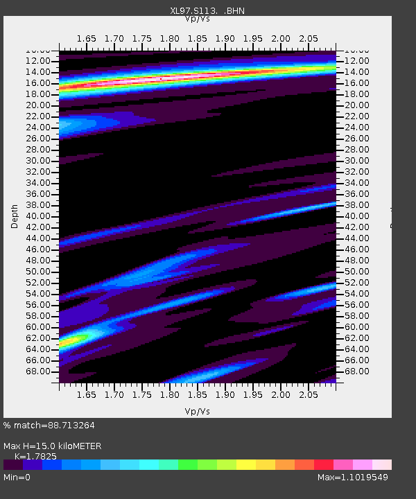
S113 LP6 pipeline - Earthquake Result Viewer
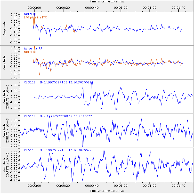
Earthquake location: Tonga Islands
Earthquake latitude/longitude: -15.2/-173.3
Earthquake time(UTC): 1997/05/27 (147) 08:00:29 GMT
Earthquake Depth: 14 km
Earthquake Magnitude: 5.6 MB, 6.3 MS, 6.4 UNKNOWN, 5.7 ME
Earthquake Catalog/Contributor: WHDF/NEIC
Network: XL Deep Probe (Archean-Proterozoic)
Station: S113 LP6 pipeline
Lat/Lon: 41.37 N/108.86 W
Elevation: 2133 m
Distance: 81.9 deg
Az: 43.32 deg
Baz: 241.639 deg
Ray Param: 0.047280364
Estimated Moho Depth: 15.0 km
Estimated Crust Vp/Vs: 1.78
Assumed Crust Vp: 6.207 km/s
Estimated Crust Vs: 3.482 km/s
Estimated Crust Poisson's Ratio: 0.27
Radial Match: 88.713264 %
Radial Bump: 342
Transverse Match: 67.408516 %
Transverse Bump: 400
SOD ConfigId: 6273
Insert Time: 2010-03-08 18:14:16.676 +0000
GWidth: 2.5
Max Bumps: 400
Tol: 0.001

Signal To Noise

ChannelStoNSTALTA
XL:S113: :BHN:19970527T08:12:16.302002Z0.99375111.3403303E-71.3487585E-7
XL:S113: :BHE:19970527T08:12:16.302002Z1.28083632.1382236E-71.6693964E-7
XL:S113: :BHZ:19970527T08:12:16.302002Z4.40586666.852051E-71.5552108E-7
Arrivals
Ps1.9 SECOND
PpPs6.6 SECOND
PsPs/PpSs8.5 SECOND