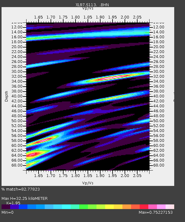
S113 LP6 pipeline - Earthquake Result Viewer
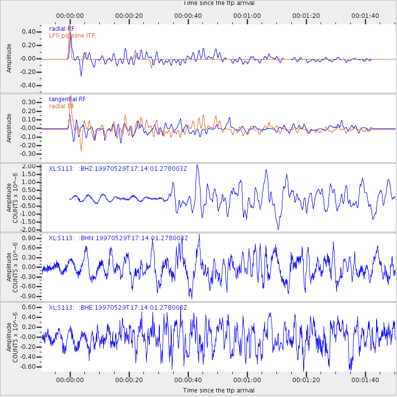
Earthquake location: Southern Pacific Ocean
Earthquake latitude/longitude: -36.0/-102.5
Earthquake time(UTC): 1997/05/29 (149) 17:02:38 GMT
Earthquake Depth: 10 km
Earthquake Magnitude: 5.6 MB, 6.1 MS, 6.5 UNKNOWN, 6.4 MW
Earthquake Catalog/Contributor: WHDF/NEIC
Network: XL Deep Probe (Archean-Proterozoic)
Station: S113 LP6 pipeline
Lat/Lon: 41.37 N/108.86 W
Elevation: 2133 m
Distance: 77.2 deg
Az: 355.102 deg
Baz: 174.72 deg
Ray Param: 0.050497994
Estimated Moho Depth: 32.25 km
Estimated Crust Vp/Vs: 1.95
Assumed Crust Vp: 6.207 km/s
Estimated Crust Vs: 3.183 km/s
Estimated Crust Poisson's Ratio: 0.32
Radial Match: 82.77823 %
Radial Bump: 400
Transverse Match: 72.71122 %
Transverse Bump: 400
SOD ConfigId: 6273
Insert Time: 2010-03-08 18:14:17.428 +0000
GWidth: 2.5
Max Bumps: 400
Tol: 0.001

Signal To Noise

ChannelStoNSTALTA
XL:S113: :BHN:19970529T17:14:01.278003Z2.18587571.9348187E-78.8514575E-8
XL:S113: :BHE:19970529T17:14:01.278003Z1.10628131.453939E-71.314258E-7
XL:S113: :BHZ:19970529T17:14:01.278003Z1.54953342.166962E-71.398461E-7
Arrivals
Ps5.1 SECOND
PpPs15 SECOND
PsPs/PpSs20 SECOND