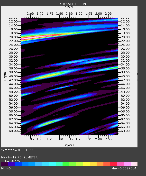
S113 LP6 pipeline - Earthquake Result Viewer
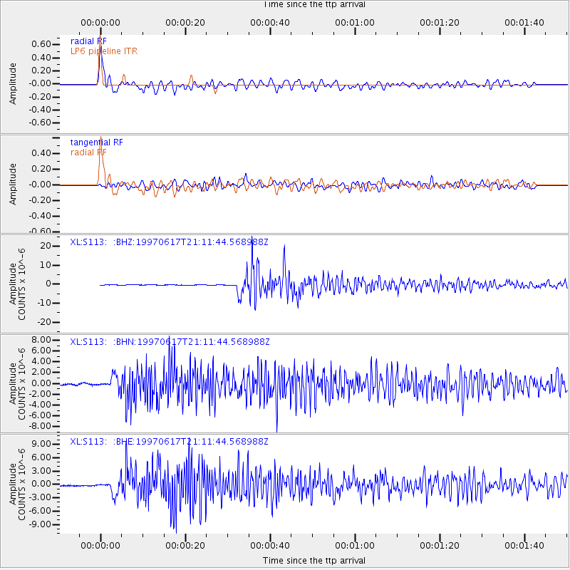
Earthquake location: Andreanof Islands, Aleutian Is.
Earthquake latitude/longitude: 51.3/-179.3
Earthquake time(UTC): 1997/06/17 (168) 21:03:40 GMT
Earthquake Depth: 33 km
Earthquake Magnitude: 6.4 MB, 6.3 MS, 6.4 UNKNOWN, 6.6 ML
Earthquake Catalog/Contributor: WHDF/NEIC
Network: XL Deep Probe (Archean-Proterozoic)
Station: S113 LP6 pipeline
Lat/Lon: 41.37 N/108.86 W
Elevation: 2133 m
Distance: 47.9 deg
Az: 72.996 deg
Baz: 307.173 deg
Ray Param: 0.069645435
Estimated Moho Depth: 19.75 km
Estimated Crust Vp/Vs: 1.68
Assumed Crust Vp: 6.207 km/s
Estimated Crust Vs: 3.7 km/s
Estimated Crust Poisson's Ratio: 0.22
Radial Match: 91.931366 %
Radial Bump: 400
Transverse Match: 79.64921 %
Transverse Bump: 400
SOD ConfigId: 6273
Insert Time: 2010-03-08 18:14:19.855 +0000
GWidth: 2.5
Max Bumps: 400
Tol: 0.001

Signal To Noise

ChannelStoNSTALTA
XL:S113: :BHN:19970617T21:11:44.568988Z11.9120351.2705071E-61.0665743E-7
XL:S113: :BHE:19970617T21:11:44.568988Z12.1108231.6047062E-61.3250184E-7
XL:S113: :BHZ:19970617T21:11:44.568988Z42.8930554.1546605E-69.686091E-8
Arrivals
Ps2.3 SECOND
PpPs8.0 SECOND
PsPs/PpSs10 SECOND