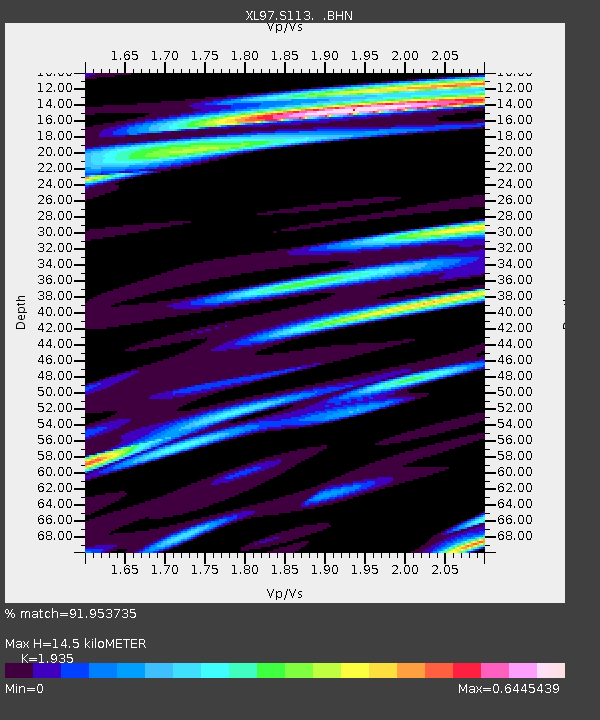
S113 LP6 pipeline - Earthquake Result Viewer
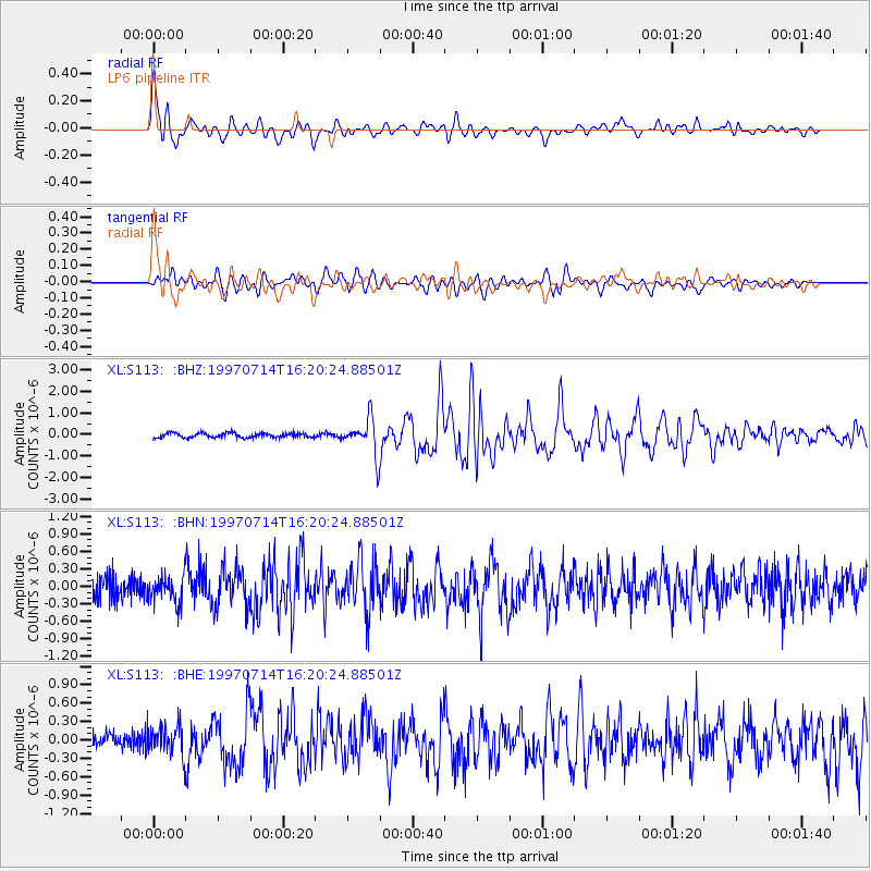
Earthquake location: Kuril Islands
Earthquake latitude/longitude: 43.2/146.4
Earthquake time(UTC): 1997/07/14 (195) 16:09:35 GMT
Earthquake Depth: 33 km
Earthquake Magnitude: 5.9 MB, 5.8 MS, 6.1 UNKNOWN, 5.8 ME
Earthquake Catalog/Contributor: WHDF/NEIC
Network: XL Deep Probe (Archean-Proterozoic)
Station: S113 LP6 pipeline
Lat/Lon: 41.37 N/108.86 W
Elevation: 2133 m
Distance: 72.0 deg
Az: 49.943 deg
Baz: 312.009 deg
Ray Param: 0.053919118
Estimated Moho Depth: 14.5 km
Estimated Crust Vp/Vs: 1.93
Assumed Crust Vp: 6.207 km/s
Estimated Crust Vs: 3.208 km/s
Estimated Crust Poisson's Ratio: 0.32
Radial Match: 91.953735 %
Radial Bump: 400
Transverse Match: 78.972725 %
Transverse Bump: 400
SOD ConfigId: 6273
Insert Time: 2010-03-08 18:14:21.837 +0000
GWidth: 2.5
Max Bumps: 400
Tol: 0.001

Signal To Noise

ChannelStoNSTALTA
XL:S113: :BHN:19970714T16:20:24.88501Z1.27898812.5475595E-71.9918555E-7
XL:S113: :BHE:19970714T16:20:24.88501Z1.53107872.6147978E-71.7078142E-7
XL:S113: :BHZ:19970714T16:20:24.88501Z7.56664138.1604793E-71.0784811E-7
Arrivals
Ps2.3 SECOND
PpPs6.7 SECOND
PsPs/PpSs8.9 SECOND