You are here: Home > Network List > ET - CERI Southern Appalachian seismic Network Stations List
> Station FPAL Fort Payne,AL > Earthquake Result Viewer
FPAL Fort Payne,AL - Earthquake Result Viewer
| Earthquake location: |
Andreanof Islands, Aleutian Is. |
| Earthquake latitude/longitude: |
51.1/-177.0 |
| Earthquake time(UTC): |
2017/05/08 (128) 15:31:28 GMT |
| Earthquake Depth: |
41 km |
| Earthquake Magnitude: |
5.5 Ml |
| Earthquake Catalog/Contributor: |
NEIC PDE/ak |
|
| Network: |
ET CERI Southern Appalachian seismic Network |
| Station: |
FPAL Fort Payne,AL |
| Lat/Lon: |
34.54 N/85.61 W |
| Elevation: |
556 m |
|
| Distance: |
64.8 deg |
| Az: |
65.745 deg |
| Baz: |
315.825 deg |
| Ray Param: |
0.05858413 |
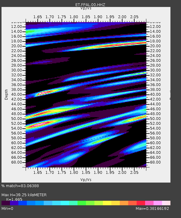
| Estimated Moho Depth: |
39.25 km |
| Estimated Crust Vp/Vs: |
1.66 |
| Assumed Crust Vp: |
6.35 km/s |
| Estimated Crust Vs: |
3.814 km/s |
| Estimated Crust Poisson's Ratio: |
0.22 |
|
| Radial Match: |
83.06388 % |
| Radial Bump: |
373 |
| Transverse Match: |
66.350815 % |
| Transverse Bump: |
384 |
| SOD ConfigId: |
2028011 |
| Insert Time: |
2017-05-22 15:33:57.571 +0000 |
| GWidth: |
2.5 |
| Max Bumps: |
400 |
| Tol: |
0.001 |
|

Signal To Noise
| Channel | StoN | STA | LTA |
| ET:FPAL:00:HHZ:20170508T15:41:32.705019Z | 6.0113373 | 5.482962E-7 | 9.121036E-8 |
| ET:FPAL:00:HHN:20170508T15:41:32.705019Z | 2.0057807 | 2.3089622E-7 | 1.15115384E-7 |
| ET:FPAL:00:HHE:20170508T15:41:32.705019Z | 1.701508 | 2.3278565E-7 | 1.3681137E-7 |
| Arrivals |
| Ps | 4.3 SECOND |
| PpPs | 16 SECOND |
| PsPs/PpSs | 20 SECOND |


