You are here: Home > Network List > TA - USArray Transportable Network (new EarthScope stations) Stations List
> Station G31M Satah River, YT, CAN > Earthquake Result Viewer
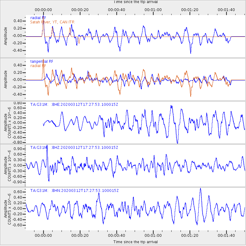
G31M Satah River, YT, CAN - Earthquake Result Viewer
*The percent match for this event was below the threshold and hence no stack was calculated.
| Earthquake location: |
Near West Coast Of Honshu, Japan |
| Earthquake latitude/longitude: |
37.3/136.9 |
| Earthquake time(UTC): |
2020/03/12 (072) 17:18:46 GMT |
| Earthquake Depth: |
10 km |
| Earthquake Magnitude: |
5.3 Mww |
| Earthquake Catalog/Contributor: |
NEIC PDE/us |
|
| Network: |
TA USArray Transportable Network (new EarthScope stations) |
| Station: |
G31M Satah River, YT, CAN |
| Lat/Lon: |
66.92 N/134.27 W |
| Elevation: |
61 m |
|
| Distance: |
55.9 deg |
| Az: |
28.419 deg |
| Baz: |
285.624 deg |
| Ray Param: |
$rayparam |
*The percent match for this event was below the threshold and hence was not used in the summary stack. |
|
| Radial Match: |
71.43351 % |
| Radial Bump: |
400 |
| Transverse Match: |
52.796104 % |
| Transverse Bump: |
307 |
| SOD ConfigId: |
20906531 |
| Insert Time: |
2020-04-08 09:49:57.181 +0000 |
| GWidth: |
2.5 |
| Max Bumps: |
400 |
| Tol: |
0.001 |
|
Signal To Noise
| Channel | StoN | STA | LTA |
| TA:G31M: :BHZ:20200312T17:27:53.100015Z | 2.7941475 | 4.222787E-7 | 1.511297E-7 |
| TA:G31M: :BHN:20200312T17:27:53.100015Z | 0.9966537 | 2.06562E-7 | 2.0725555E-7 |
| TA:G31M: :BHE:20200312T17:27:53.100015Z | 1.3571402 | 2.271621E-7 | 1.6738294E-7 |
| Arrivals |
| Ps | |
| PpPs | |
| PsPs/PpSs | |


