You are here: Home > Network List > US - United States National Seismic Network Stations List
> Station EGMT Eagleton, Montana, USA > Earthquake Result Viewer
EGMT Eagleton, Montana, USA - Earthquake Result Viewer
*The percent match for this event was below the threshold and hence no stack was calculated.
| Earthquake location: |
Near West Coast Of Honshu, Japan |
| Earthquake latitude/longitude: |
37.3/136.9 |
| Earthquake time(UTC): |
2020/03/12 (072) 17:18:46 GMT |
| Earthquake Depth: |
10 km |
| Earthquake Magnitude: |
5.3 Mww |
| Earthquake Catalog/Contributor: |
NEIC PDE/us |
|
| Network: |
US United States National Seismic Network |
| Station: |
EGMT Eagleton, Montana, USA |
| Lat/Lon: |
48.02 N/109.75 W |
| Elevation: |
1055 m |
|
| Distance: |
76.4 deg |
| Az: |
39.341 deg |
| Baz: |
311.124 deg |
| Ray Param: |
$rayparam |
*The percent match for this event was below the threshold and hence was not used in the summary stack. |
|
| Radial Match: |
42.24745 % |
| Radial Bump: |
400 |
| Transverse Match: |
50.047726 % |
| Transverse Bump: |
400 |
| SOD ConfigId: |
20906531 |
| Insert Time: |
2020-04-08 09:52:26.832 +0000 |
| GWidth: |
2.5 |
| Max Bumps: |
400 |
| Tol: |
0.001 |
|
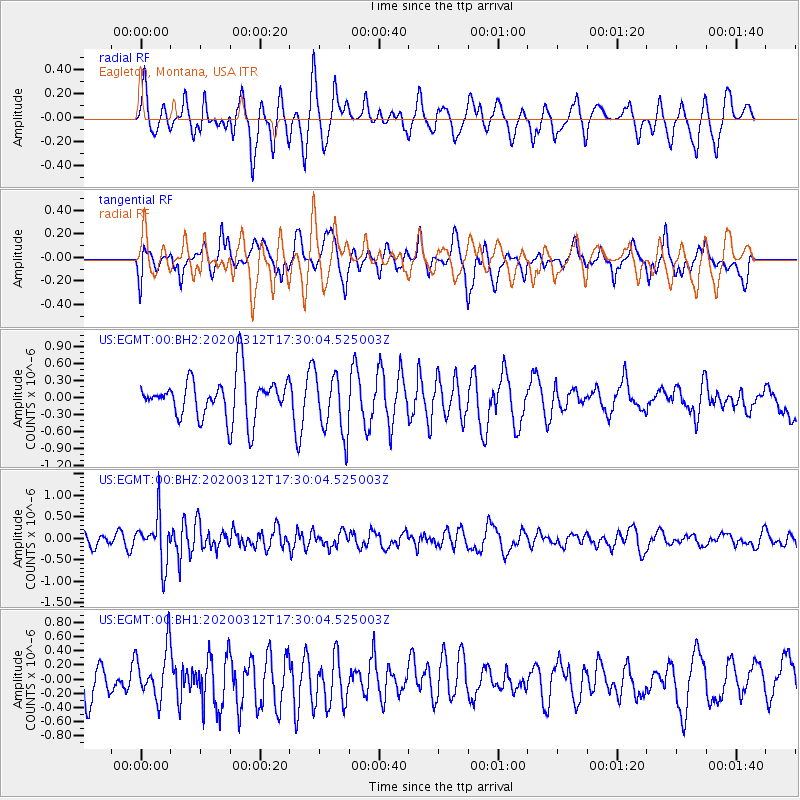
Signal To Noise
| Channel | StoN | STA | LTA |
| US:EGMT:00:BHZ:20200312T17:30:04.525003Z | 3.8936052 | 5.4778707E-7 | 1.406889E-7 |
| US:EGMT:00:BH1:20200312T17:30:04.525003Z | 1.0491694 | 3.6342124E-7 | 3.463895E-7 |
| US:EGMT:00:BH2:20200312T17:30:04.525003Z | 1.4727297 | 5.4551145E-7 | 3.7040843E-7 |
| Arrivals |
| Ps | |
| PpPs | |
| PsPs/PpSs | |


