You are here: Home > Network List > US - United States National Seismic Network Stations List
> Station HDIL Hopedale, Illinois, USA > Earthquake Result Viewer
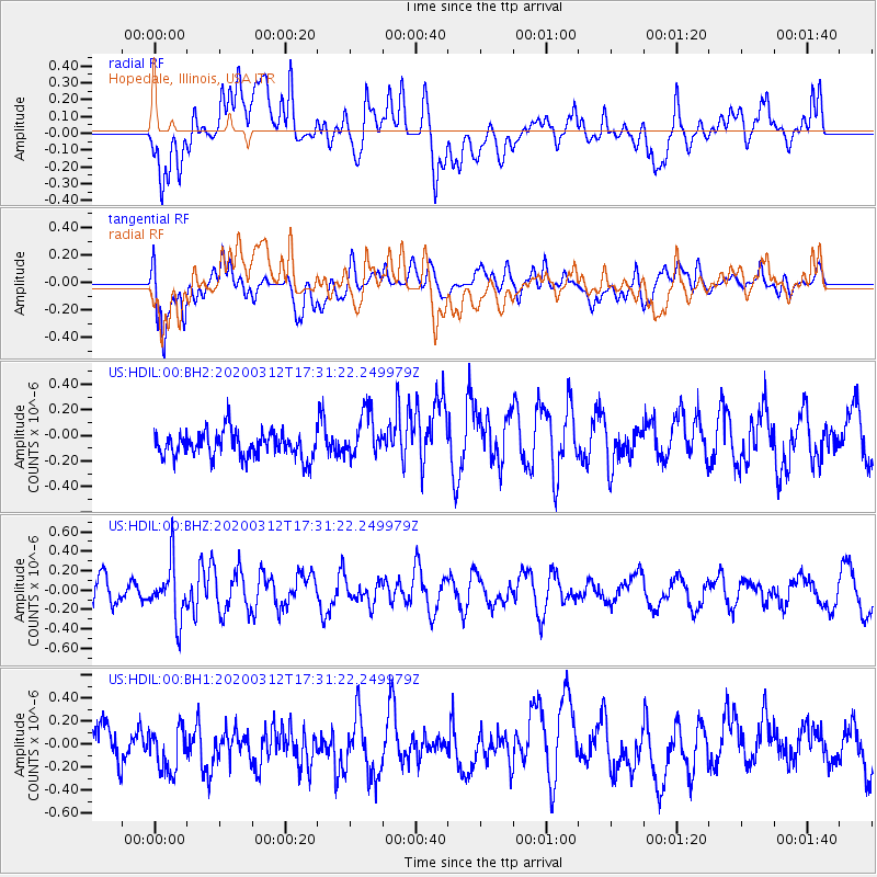
HDIL Hopedale, Illinois, USA - Earthquake Result Viewer
*The percent match for this event was below the threshold and hence no stack was calculated.
| Earthquake location: |
Near West Coast Of Honshu, Japan |
| Earthquake latitude/longitude: |
37.3/136.9 |
| Earthquake time(UTC): |
2020/03/12 (072) 17:18:46 GMT |
| Earthquake Depth: |
10 km |
| Earthquake Magnitude: |
5.3 Mww |
| Earthquake Catalog/Contributor: |
NEIC PDE/us |
|
| Network: |
US United States National Seismic Network |
| Station: |
HDIL Hopedale, Illinois, USA |
| Lat/Lon: |
40.56 N/89.29 W |
| Elevation: |
219 m |
|
| Distance: |
91.7 deg |
| Az: |
33.362 deg |
| Baz: |
324.848 deg |
| Ray Param: |
$rayparam |
*The percent match for this event was below the threshold and hence was not used in the summary stack. |
|
| Radial Match: |
67.56981 % |
| Radial Bump: |
400 |
| Transverse Match: |
50.91485 % |
| Transverse Bump: |
400 |
| SOD ConfigId: |
20906531 |
| Insert Time: |
2020-04-08 09:52:30.196 +0000 |
| GWidth: |
2.5 |
| Max Bumps: |
400 |
| Tol: |
0.001 |
|
Signal To Noise
| Channel | StoN | STA | LTA |
| US:HDIL:00:BHZ:20200312T17:31:22.249979Z | 2.1166992 | 2.8379807E-7 | 1.3407576E-7 |
| US:HDIL:00:BH1:20200312T17:31:22.249979Z | 0.811797 | 2.0027367E-7 | 2.4670413E-7 |
| US:HDIL:00:BH2:20200312T17:31:22.249979Z | 1.8188183 | 1.8311118E-7 | 1.00675905E-7 |
| Arrivals |
| Ps | |
| PpPs | |
| PsPs/PpSs | |


