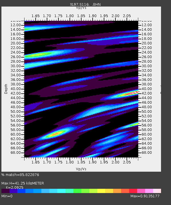
S116 19 South Road - Earthquake Result Viewer
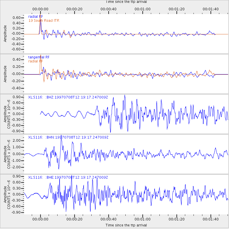
Earthquake location: Andreanof Islands, Aleutian Is.
Earthquake latitude/longitude: 51.4/-178.6
Earthquake time(UTC): 1997/07/08 (189) 12:11:15 GMT
Earthquake Depth: 33 km
Earthquake Magnitude: 5.5 MB, 5.4 MS, 5.8 UNKNOWN, 5.6 ML
Earthquake Catalog/Contributor: WHDF/NEIC
Network: XL Deep Probe (Archean-Proterozoic)
Station: S116 19 South Road
Lat/Lon: 41.11 N/108.81 W
Elevation: 2230 m
Distance: 47.6 deg
Az: 73.725 deg
Baz: 307.224 deg
Ray Param: 0.06981282
Estimated Moho Depth: 41.25 km
Estimated Crust Vp/Vs: 2.09
Assumed Crust Vp: 6.207 km/s
Estimated Crust Vs: 2.966 km/s
Estimated Crust Poisson's Ratio: 0.35
Radial Match: 85.822876 %
Radial Bump: 400
Transverse Match: 77.215996 %
Transverse Bump: 400
SOD ConfigId: 4480
Insert Time: 2010-03-08 18:14:49.093 +0000
GWidth: 2.5
Max Bumps: 400
Tol: 0.001

Signal To Noise

ChannelStoNSTALTA
XL:S116: :BHN:19970708T12:19:17.247009Z4.0797534.919714E-71.2058852E-7
XL:S116: :BHE:19970708T12:19:17.247009Z1.0785161.12763836E-71.04554616E-7
XL:S116: :BHZ:19970708T12:19:17.247009Z1.89216861.7808397E-79.411633E-8
Arrivals
Ps7.6 SECOND
PpPs20 SECOND
PsPs/PpSs27 SECOND