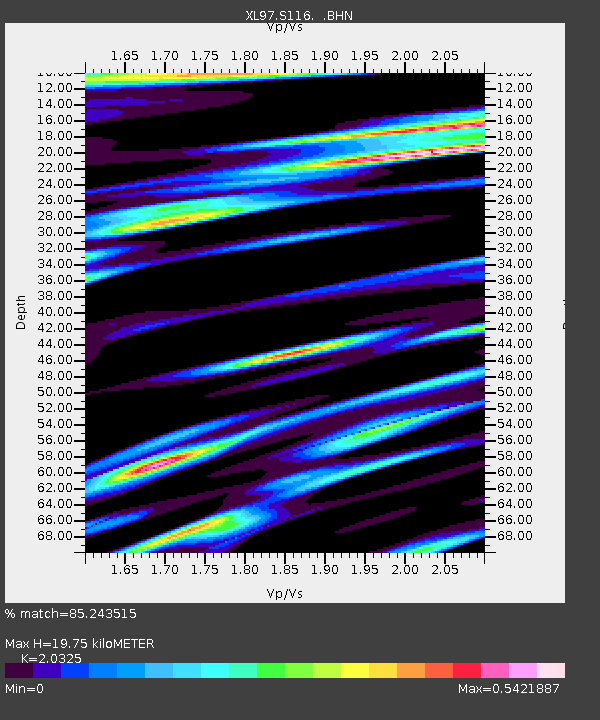
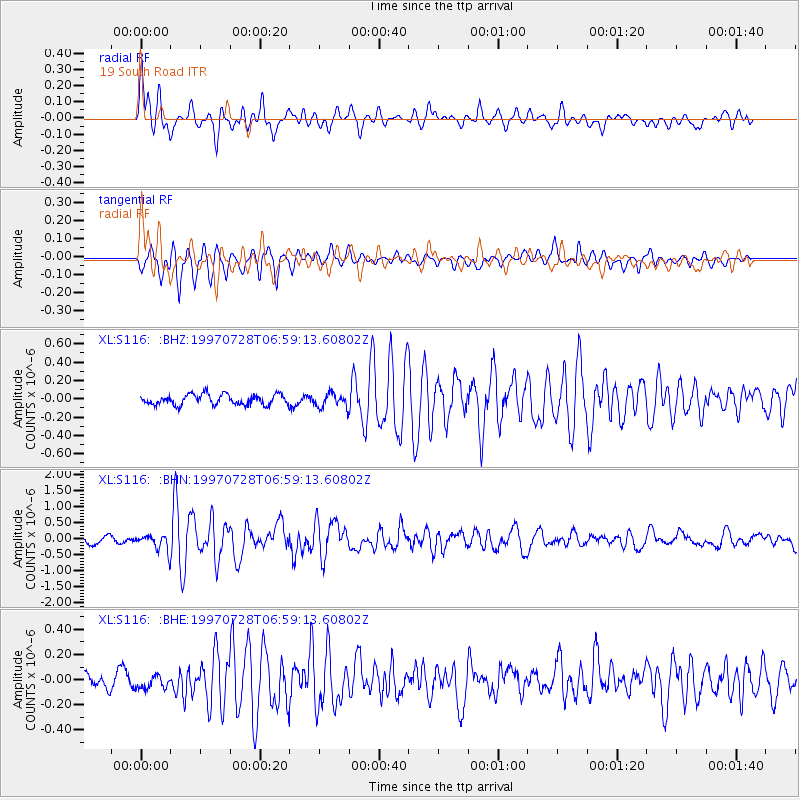
S116 19 South Road - Earthquake Result Viewer

Earthquake location: Volcano Islands, Japan Region
Earthquake latitude/longitude: 22.4/142.7
Earthquake time(UTC): 1997/07/28 (209) 06:46:55 GMT
Earthquake Depth: 33 km
Earthquake Magnitude: 5.7 MB, 5.8 MS, 5.9 UNKNOWN, 5.9 MW
Earthquake Catalog/Contributor: WHDF/NEIC
Network: XL Deep Probe (Archean-Proterozoic)
Station: S116 19 South Road
Lat/Lon: 41.11 N/108.81 W
Elevation: 2230 m
Distance: 88.5 deg
Az: 45.808 deg
Baz: 298.55 deg
Ray Param: 0.042500634
Estimated Moho Depth: 19.75 km
Estimated Crust Vp/Vs: 2.03
Assumed Crust Vp: 6.207 km/s
Estimated Crust Vs: 3.054 km/s
Estimated Crust Poisson's Ratio: 0.34
Radial Match: 85.243515 %
Radial Bump: 400
Transverse Match: 85.70666 %
Transverse Bump: 384
SOD ConfigId: 4480
Insert Time: 2010-03-08 18:14:49.849 +0000
GWidth: 2.5
Max Bumps: 400
Tol: 0.001

Signal To Noise

ChannelStoNSTALTA
XL:S116: :BHN:19970728T06:59:13.60802Z2.3667092.6711925E-71.12865266E-7
XL:S116: :BHE:19970728T06:59:13.60802Z1.08752855.4217836E-84.9854172E-8
XL:S116: :BHZ:19970728T06:59:13.60802Z1.32085767.443883E-85.6356438E-8
Arrivals
Ps3.3 SECOND
PpPs9.5 SECOND
PsPs/PpSs13 SECOND