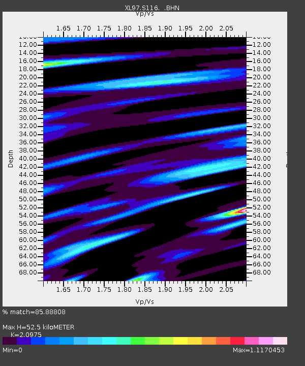
S116 19 South Road - Earthquake Result Viewer
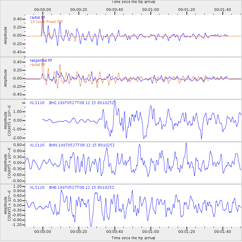
Earthquake location: Tonga Islands
Earthquake latitude/longitude: -15.2/-173.3
Earthquake time(UTC): 1997/05/27 (147) 08:00:29 GMT
Earthquake Depth: 14 km
Earthquake Magnitude: 5.6 MB, 6.3 MS, 6.4 UNKNOWN, 5.7 ME
Earthquake Catalog/Contributor: WHDF/NEIC
Network: XL Deep Probe (Archean-Proterozoic)
Station: S116 19 South Road
Lat/Lon: 41.11 N/108.81 W
Elevation: 2230 m
Distance: 81.8 deg
Az: 43.569 deg
Baz: 241.71 deg
Ray Param: 0.04734172
Estimated Moho Depth: 52.5 km
Estimated Crust Vp/Vs: 2.10
Assumed Crust Vp: 6.207 km/s
Estimated Crust Vs: 2.959 km/s
Estimated Crust Poisson's Ratio: 0.35
Radial Match: 85.88808 %
Radial Bump: 400
Transverse Match: 83.38863 %
Transverse Bump: 400
SOD ConfigId: 6273
Insert Time: 2010-03-08 18:14:50.593 +0000
GWidth: 2.5
Max Bumps: 400
Tol: 0.001

Signal To Noise

ChannelStoNSTALTA
XL:S116: :BHN:19970527T08:12:15.801025Z0.85048681.12700846E-71.3251334E-7
XL:S116: :BHE:19970527T08:12:15.801025Z0.89448231.4251744E-71.5932952E-7
XL:S116: :BHZ:19970527T08:12:15.801025Z3.70111785.079064E-71.3723054E-7
Arrivals
Ps9.5 SECOND
PpPs26 SECOND
PsPs/PpSs35 SECOND