You are here: Home > Network List > TS - TERRAscope (Southern California Seismic Network) Stations List
> Station PFO Pinon Flat, California, USA > Earthquake Result Viewer
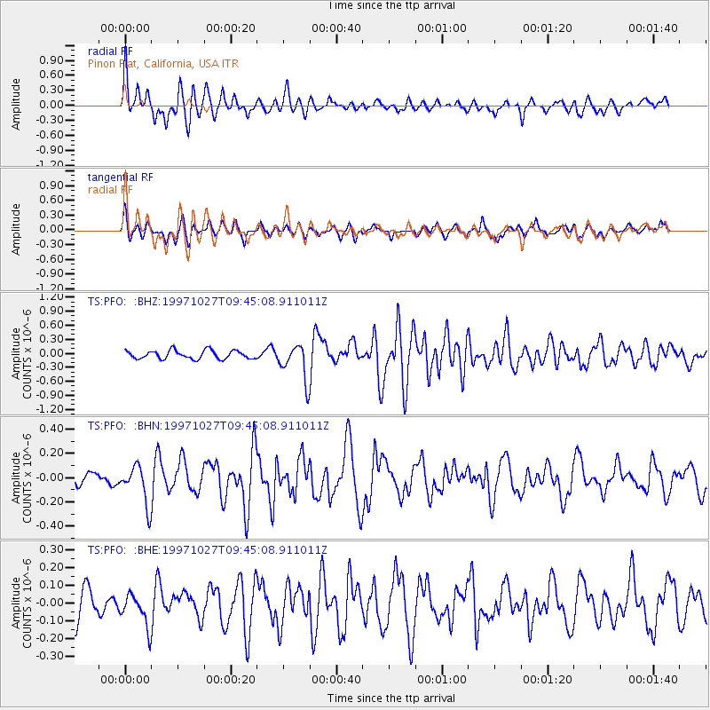
PFO Pinon Flat, California, USA - Earthquake Result Viewer
*The percent match for this event was below the threshold and hence no stack was calculated.
| Earthquake location: |
Kermadec Islands, New Zealand |
| Earthquake latitude/longitude: |
-30.8/-178.5 |
| Earthquake time(UTC): |
1997/10/27 (300) 09:32:59 GMT |
| Earthquake Depth: |
33 km |
| Earthquake Magnitude: |
5.5 MB, 5.4 MS |
| Earthquake Catalog/Contributor: |
WHDF/NEIC |
|
| Network: |
TS TERRAscope (Southern California Seismic Network) |
| Station: |
PFO Pinon Flat, California, USA |
| Lat/Lon: |
33.61 N/116.46 W |
| Elevation: |
1280 m |
|
| Distance: |
86.7 deg |
| Az: |
47.563 deg |
| Baz: |
229.576 deg |
| Ray Param: |
$rayparam |
*The percent match for this event was below the threshold and hence was not used in the summary stack. |
|
| Radial Match: |
50.293724 % |
| Radial Bump: |
400 |
| Transverse Match: |
52.942223 % |
| Transverse Bump: |
400 |
| SOD ConfigId: |
4480 |
| Insert Time: |
2010-02-26 14:43:59.216 +0000 |
| GWidth: |
2.5 |
| Max Bumps: |
400 |
| Tol: |
0.001 |
|
Signal To Noise
| Channel | StoN | STA | LTA |
| TS:PFO: :BHN:19971027T09:45:08.911011Z | 1.9276352 | 1.6277522E-7 | 8.444296E-8 |
| TS:PFO: :BHE:19971027T09:45:08.911011Z | 0.9617016 | 9.21767E-8 | 9.584751E-8 |
| TS:PFO: :BHZ:19971027T09:45:08.911011Z | 4.3467493 | 3.904286E-7 | 8.982082E-8 |
| Arrivals |
| Ps | |
| PpPs | |
| PsPs/PpSs | |


