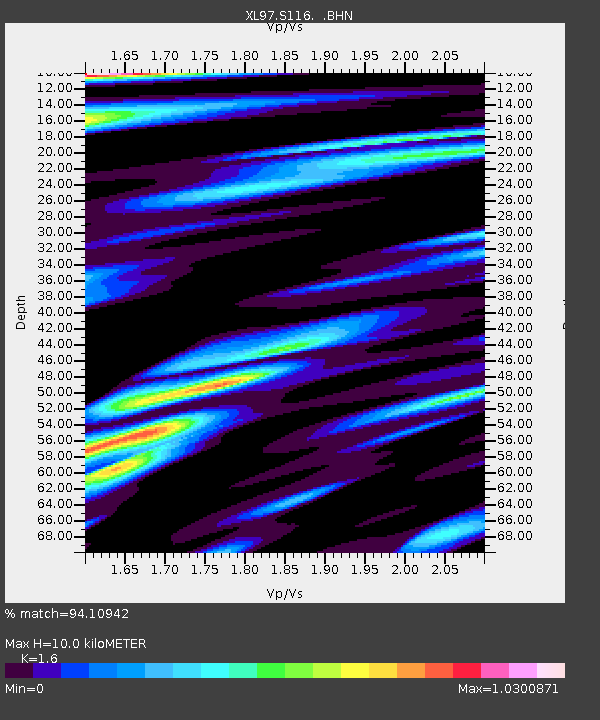
S116 19 South Road - Earthquake Result Viewer
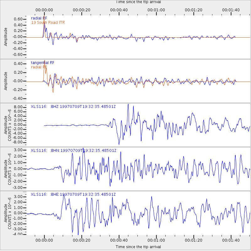
Earthquake location: Near Coast Of Venezuela
Earthquake latitude/longitude: 10.6/-63.5
Earthquake time(UTC): 1997/07/09 (190) 19:24:13 GMT
Earthquake Depth: 20 km
Earthquake Magnitude: 6.2 MB, 6.8 MS, 7.0 UNKNOWN, 6.6 ME
Earthquake Catalog/Contributor: WHDF/NEIC
Network: XL Deep Probe (Archean-Proterozoic)
Station: S116 19 South Road
Lat/Lon: 41.11 N/108.81 W
Elevation: 2230 m
Distance: 50.1 deg
Az: 315.505 deg
Baz: 114.235 deg
Ray Param: 0.06828287
Estimated Moho Depth: 10.0 km
Estimated Crust Vp/Vs: 1.60
Assumed Crust Vp: 6.207 km/s
Estimated Crust Vs: 3.879 km/s
Estimated Crust Poisson's Ratio: 0.18
Radial Match: 94.10942 %
Radial Bump: 400
Transverse Match: 82.66388 %
Transverse Bump: 400
SOD ConfigId: 6273
Insert Time: 2010-03-08 18:14:52.903 +0000
GWidth: 2.5
Max Bumps: 400
Tol: 0.001

Signal To Noise

ChannelStoNSTALTA
XL:S116: :BHN:19970709T19:32:35.48501Z0.561838757.179812E-81.2779132E-7
XL:S116: :BHE:19970709T19:32:35.48501Z2.61057421.9050991E-77.297625E-8
XL:S116: :BHZ:19970709T19:32:35.48501Z2.37882662.3989386E-71.0084546E-7
Arrivals
Ps1.0 SECOND
PpPs3.9 SECOND
PsPs/PpSs5.0 SECOND