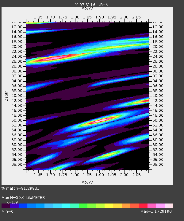
S116 19 South Road - Earthquake Result Viewer
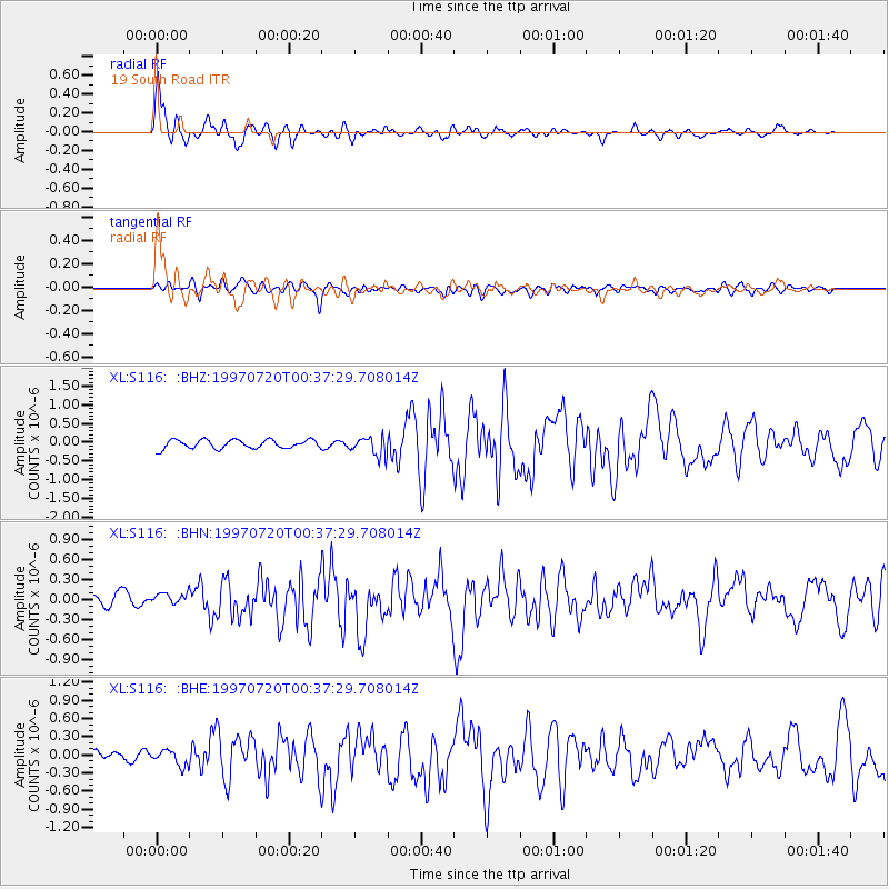
Earthquake location: Fox Islands, Aleutian Islands
Earthquake latitude/longitude: 52.6/-167.5
Earthquake time(UTC): 1997/07/20 (201) 00:30:20 GMT
Earthquake Depth: 14 km
Earthquake Magnitude: 5.6 MB, 5.9 MS, 6.2 UNKNOWN, 6.2 MW
Earthquake Catalog/Contributor: WHDF/NEIC
Network: XL Deep Probe (Archean-Proterozoic)
Station: S116 19 South Road
Lat/Lon: 41.11 N/108.81 W
Elevation: 2230 m
Distance: 40.7 deg
Az: 82.175 deg
Baz: 306.834 deg
Ray Param: 0.074261546
Estimated Moho Depth: 50.0 km
Estimated Crust Vp/Vs: 1.90
Assumed Crust Vp: 6.207 km/s
Estimated Crust Vs: 3.267 km/s
Estimated Crust Poisson's Ratio: 0.31
Radial Match: 91.29931 %
Radial Bump: 400
Transverse Match: 67.01517 %
Transverse Bump: 400
SOD ConfigId: 6273
Insert Time: 2010-03-08 18:14:55.109 +0000
GWidth: 2.5
Max Bumps: 400
Tol: 0.001

Signal To Noise

ChannelStoNSTALTA
XL:S116: :BHN:19970720T00:37:29.708014Z0.90222138.586591E-89.517167E-8
XL:S116: :BHE:19970720T00:37:29.708014Z1.20526921.232112E-71.0222712E-7
XL:S116: :BHZ:19970720T00:37:29.708014Z2.16119962.4927485E-71.15340974E-7
Arrivals
Ps7.7 SECOND
PpPs22 SECOND
PsPs/PpSs30 SECOND