You are here: Home > Network List > AU - Australian Seismological Centre Stations List
> Station XMI Christmas Island Airport > Earthquake Result Viewer
XMI Christmas Island Airport - Earthquake Result Viewer
| Earthquake location: |
Kermadec Islands Region |
| Earthquake latitude/longitude: |
-27.4/-175.7 |
| Earthquake time(UTC): |
2020/03/14 (074) 10:01:17 GMT |
| Earthquake Depth: |
10 km |
| Earthquake Magnitude: |
6.3 Mww |
| Earthquake Catalog/Contributor: |
NEIC PDE/us |
|
| Network: |
AU Australian Seismological Centre |
| Station: |
XMI Christmas Island Airport |
| Lat/Lon: |
10.45 S/105.69 E |
| Elevation: |
252 m |
|
| Distance: |
75.2 deg |
| Az: |
265.769 deg |
| Baz: |
115.677 deg |
| Ray Param: |
0.051810857 |
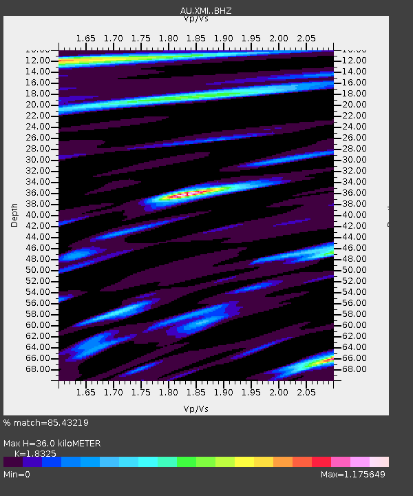
| Estimated Moho Depth: |
36.0 km |
| Estimated Crust Vp/Vs: |
1.83 |
| Assumed Crust Vp: |
4.157 km/s |
| Estimated Crust Vs: |
2.268 km/s |
| Estimated Crust Poisson's Ratio: |
0.29 |
|
| Radial Match: |
85.43219 % |
| Radial Bump: |
400 |
| Transverse Match: |
78.27196 % |
| Transverse Bump: |
400 |
| SOD ConfigId: |
20906531 |
| Insert Time: |
2020-04-08 10:16:18.404 +0000 |
| GWidth: |
2.5 |
| Max Bumps: |
400 |
| Tol: |
0.001 |
|

Signal To Noise
| Channel | StoN | STA | LTA |
| AU:XMI: :BHZ:20200314T10:12:28.843999Z | 2.3631034 | 2.9354958E-6 | 1.2422206E-6 |
| AU:XMI: :BHN:20200314T10:12:28.843999Z | 1.2042215 | 1.1188022E-6 | 9.2906686E-7 |
| AU:XMI: :BHE:20200314T10:12:28.843999Z | 1.1145909 | 1.0000188E-6 | 8.972071E-7 |
| Arrivals |
| Ps | 7.3 SECOND |
| PpPs | 24 SECOND |
| PsPs/PpSs | 32 SECOND |


