You are here: Home > Network List > AV - Alaska Volcano Observatory Stations List
> Station ILS Iliamna South, Iliamna Volcano, Alaska > Earthquake Result Viewer
ILS Iliamna South, Iliamna Volcano, Alaska - Earthquake Result Viewer
| Earthquake location: |
Kermadec Islands Region |
| Earthquake latitude/longitude: |
-27.4/-175.7 |
| Earthquake time(UTC): |
2020/03/14 (074) 10:01:17 GMT |
| Earthquake Depth: |
10 km |
| Earthquake Magnitude: |
6.3 Mww |
| Earthquake Catalog/Contributor: |
NEIC PDE/us |
|
| Network: |
AV Alaska Volcano Observatory |
| Station: |
ILS Iliamna South, Iliamna Volcano, Alaska |
| Lat/Lon: |
59.96 N/153.07 W |
| Elevation: |
1125 m |
|
| Distance: |
89.0 deg |
| Az: |
11.158 deg |
| Baz: |
199.99 deg |
| Ray Param: |
0.04215792 |
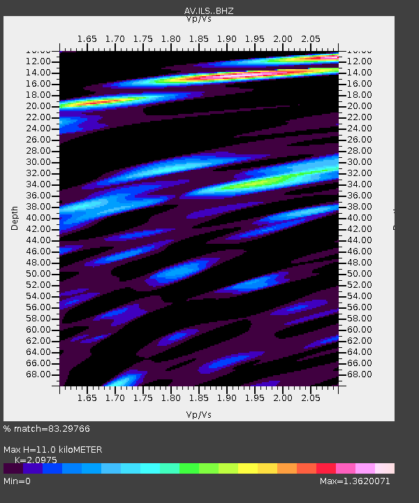
| Estimated Moho Depth: |
11.0 km |
| Estimated Crust Vp/Vs: |
2.10 |
| Assumed Crust Vp: |
5.989 km/s |
| Estimated Crust Vs: |
2.855 km/s |
| Estimated Crust Poisson's Ratio: |
0.35 |
|
| Radial Match: |
83.29766 % |
| Radial Bump: |
400 |
| Transverse Match: |
78.99903 % |
| Transverse Bump: |
400 |
| SOD ConfigId: |
20906531 |
| Insert Time: |
2020-04-08 10:17:05.902 +0000 |
| GWidth: |
2.5 |
| Max Bumps: |
400 |
| Tol: |
0.001 |
|

Signal To Noise
| Channel | StoN | STA | LTA |
| AV:ILS: :BHZ:20200314T10:13:40.878972Z | 10.7835655 | 1.7193954E-6 | 1.5944592E-7 |
| AV:ILS: :BHN:20200314T10:13:40.878972Z | 6.1181135 | 8.212588E-7 | 1.34234E-7 |
| AV:ILS: :BHE:20200314T10:13:40.878972Z | 4.576102 | 7.7968394E-7 | 1.703817E-7 |
| Arrivals |
| Ps | 2.0 SECOND |
| PpPs | 5.6 SECOND |
| PsPs/PpSs | 7.6 SECOND |


