You are here: Home > Network List > US - United States National Seismic Network Stations List
> Station AMTX Amarillo, Texas, USA > Earthquake Result Viewer
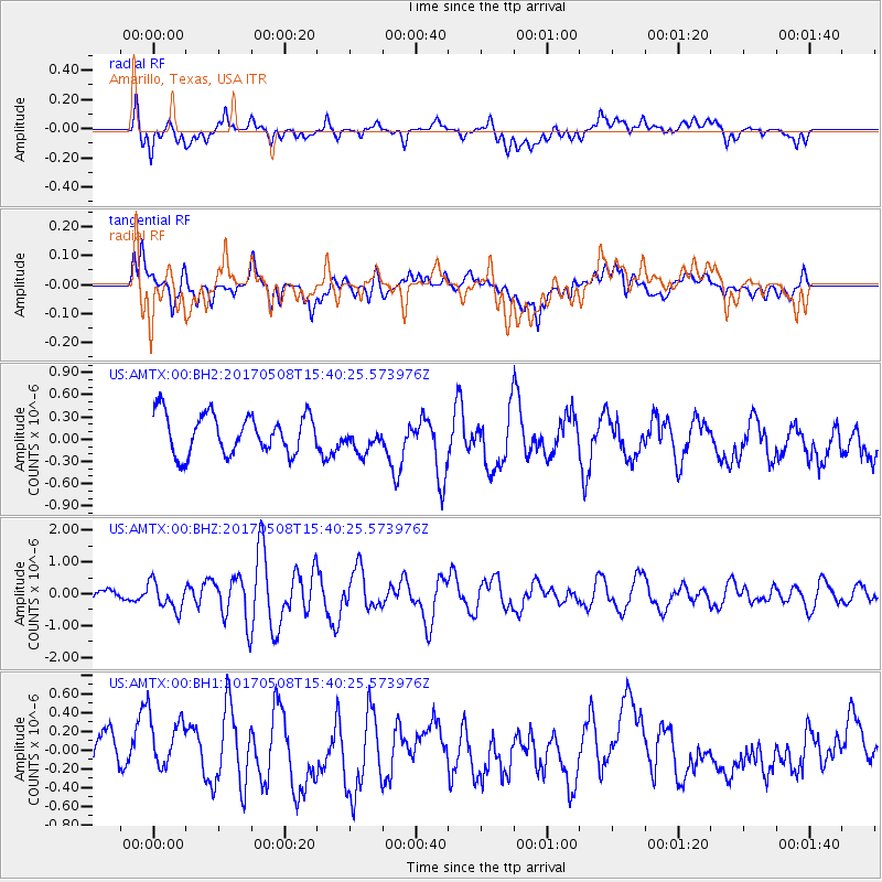
AMTX Amarillo, Texas, USA - Earthquake Result Viewer
*The percent match for this event was below the threshold and hence no stack was calculated.
| Earthquake location: |
Andreanof Islands, Aleutian Is. |
| Earthquake latitude/longitude: |
51.1/-177.0 |
| Earthquake time(UTC): |
2017/05/08 (128) 15:31:28 GMT |
| Earthquake Depth: |
41 km |
| Earthquake Magnitude: |
5.5 Ml |
| Earthquake Catalog/Contributor: |
NEIC PDE/ak |
|
| Network: |
US United States National Seismic Network |
| Station: |
AMTX Amarillo, Texas, USA |
| Lat/Lon: |
34.53 N/101.41 W |
| Elevation: |
1010 m |
|
| Distance: |
55.4 deg |
| Az: |
76.172 deg |
| Baz: |
312.09 deg |
| Ray Param: |
$rayparam |
*The percent match for this event was below the threshold and hence was not used in the summary stack. |
|
| Radial Match: |
50.82423 % |
| Radial Bump: |
400 |
| Transverse Match: |
61.755527 % |
| Transverse Bump: |
400 |
| SOD ConfigId: |
2028011 |
| Insert Time: |
2017-05-22 15:36:42.836 +0000 |
| GWidth: |
2.5 |
| Max Bumps: |
400 |
| Tol: |
0.001 |
|
Signal To Noise
| Channel | StoN | STA | LTA |
| US:AMTX:00:BHZ:20170508T15:40:25.573976Z | 1.6412685 | 4.3649823E-7 | 2.6595177E-7 |
| US:AMTX:00:BH1:20170508T15:40:25.573976Z | 1.3791425 | 2.9488993E-7 | 2.1382121E-7 |
| US:AMTX:00:BH2:20170508T15:40:25.573976Z | 1.2380989 | 3.0560187E-7 | 2.4683155E-7 |
| Arrivals |
| Ps | |
| PpPs | |
| PsPs/PpSs | |


