You are here: Home > Network List > AV - Alaska Volcano Observatory Stations List
> Station WACK Chichokna Glacier, Wrangell, Alaska > Earthquake Result Viewer
WACK Chichokna Glacier, Wrangell, Alaska - Earthquake Result Viewer
| Earthquake location: |
Kermadec Islands Region |
| Earthquake latitude/longitude: |
-27.4/-175.7 |
| Earthquake time(UTC): |
2020/03/14 (074) 10:01:17 GMT |
| Earthquake Depth: |
10 km |
| Earthquake Magnitude: |
6.3 Mww |
| Earthquake Catalog/Contributor: |
NEIC PDE/us |
|
| Network: |
AV Alaska Volcano Observatory |
| Station: |
WACK Chichokna Glacier, Wrangell, Alaska |
| Lat/Lon: |
61.99 N/144.33 W |
| Elevation: |
2280 m |
|
| Distance: |
92.6 deg |
| Az: |
14.237 deg |
| Baz: |
207.581 deg |
| Ray Param: |
0.041429967 |
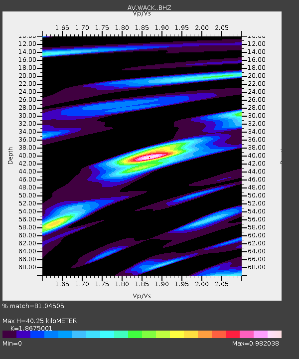
| Estimated Moho Depth: |
40.25 km |
| Estimated Crust Vp/Vs: |
1.87 |
| Assumed Crust Vp: |
6.566 km/s |
| Estimated Crust Vs: |
3.516 km/s |
| Estimated Crust Poisson's Ratio: |
0.30 |
|
| Radial Match: |
81.04505 % |
| Radial Bump: |
400 |
| Transverse Match: |
78.15754 % |
| Transverse Bump: |
400 |
| SOD ConfigId: |
20906531 |
| Insert Time: |
2020-04-08 10:18:04.713 +0000 |
| GWidth: |
2.5 |
| Max Bumps: |
400 |
| Tol: |
0.001 |
|

Signal To Noise
| Channel | StoN | STA | LTA |
| AV:WACK: :BHZ:20200314T10:13:57.419987Z | 14.152664 | 1.3046466E-6 | 9.218382E-8 |
| AV:WACK: :BHN:20200314T10:13:57.419987Z | 2.8066254 | 4.926107E-7 | 1.7551707E-7 |
| AV:WACK: :BHE:20200314T10:13:57.419987Z | 1.8321528 | 2.6129015E-7 | 1.4261373E-7 |
| Arrivals |
| Ps | 5.4 SECOND |
| PpPs | 17 SECOND |
| PsPs/PpSs | 23 SECOND |


