You are here: Home > Network List > TS - TERRAscope (Southern California Seismic Network) Stations List
> Station PFO Pinon Flat, California, USA > Earthquake Result Viewer
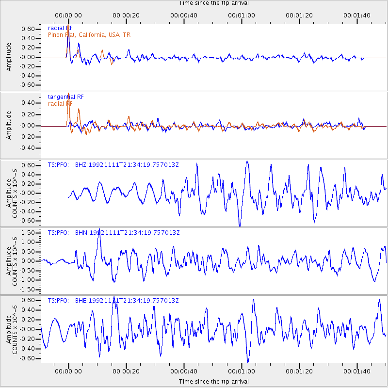
PFO Pinon Flat, California, USA - Earthquake Result Viewer
*The percent match for this event was below the threshold and hence no stack was calculated.
| Earthquake location: |
Andreanof Islands, Aleutian Is. |
| Earthquake latitude/longitude: |
51.2/-179.2 |
| Earthquake time(UTC): |
1992/11/11 (316) 21:26:14 GMT |
| Earthquake Depth: |
33 km |
| Earthquake Magnitude: |
5.7 MB, 5.8 MS, 5.6 UNKNOWN, 5.9 ML |
| Earthquake Catalog/Contributor: |
WHDF/NEIC |
|
| Network: |
TS TERRAscope (Southern California Seismic Network) |
| Station: |
PFO Pinon Flat, California, USA |
| Lat/Lon: |
33.61 N/116.46 W |
| Elevation: |
1280 m |
|
| Distance: |
48.1 deg |
| Az: |
86.131 deg |
| Baz: |
311.198 deg |
| Ray Param: |
$rayparam |
*The percent match for this event was below the threshold and hence was not used in the summary stack. |
|
| Radial Match: |
79.494316 % |
| Radial Bump: |
400 |
| Transverse Match: |
58.662285 % |
| Transverse Bump: |
400 |
| SOD ConfigId: |
4480 |
| Insert Time: |
2010-02-26 14:44:02.378 +0000 |
| GWidth: |
2.5 |
| Max Bumps: |
400 |
| Tol: |
0.001 |
|
Signal To Noise
| Channel | StoN | STA | LTA |
| TS:PFO: :BHN:19921111T21:34:19.757013Z | 1.7029077 | 2.2452893E-7 | 1.3185033E-7 |
| TS:PFO: :BHE:19921111T21:34:19.757013Z | 0.51330405 | 1.03775086E-7 | 2.021708E-7 |
| TS:PFO: :BHZ:19921111T21:34:19.757013Z | 1.431129 | 1.5548846E-7 | 1.0864741E-7 |
| Arrivals |
| Ps | |
| PpPs | |
| PsPs/PpSs | |


