You are here: Home > Network List > CC - Cascade Chain Volcano Monitoring Stations List
> Station SIFT Swift Creek > Earthquake Result Viewer
SIFT Swift Creek - Earthquake Result Viewer
| Earthquake location: |
Kermadec Islands Region |
| Earthquake latitude/longitude: |
-27.4/-175.7 |
| Earthquake time(UTC): |
2020/03/14 (074) 10:01:17 GMT |
| Earthquake Depth: |
10 km |
| Earthquake Magnitude: |
6.3 Mww |
| Earthquake Catalog/Contributor: |
NEIC PDE/us |
|
| Network: |
CC Cascade Chain Volcano Monitoring |
| Station: |
SIFT Swift Creek |
| Lat/Lon: |
46.87 N/121.95 W |
| Elevation: |
732 m |
|
| Distance: |
88.4 deg |
| Az: |
33.601 deg |
| Baz: |
225.804 deg |
| Ray Param: |
0.042601597 |
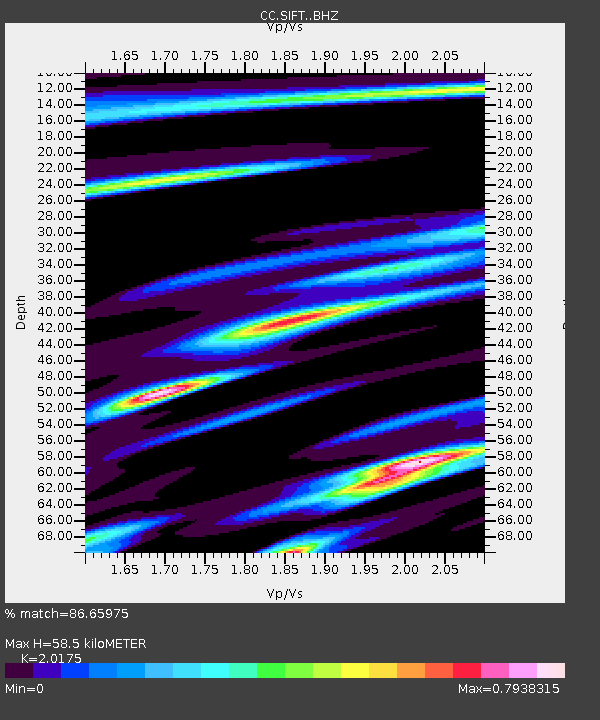
| Estimated Moho Depth: |
58.5 km |
| Estimated Crust Vp/Vs: |
2.02 |
| Assumed Crust Vp: |
6.597 km/s |
| Estimated Crust Vs: |
3.27 km/s |
| Estimated Crust Poisson's Ratio: |
0.34 |
|
| Radial Match: |
86.65975 % |
| Radial Bump: |
400 |
| Transverse Match: |
72.74542 % |
| Transverse Bump: |
400 |
| SOD ConfigId: |
20906531 |
| Insert Time: |
2020-04-08 10:21:16.606 +0000 |
| GWidth: |
2.5 |
| Max Bumps: |
400 |
| Tol: |
0.001 |
|

Signal To Noise
| Channel | StoN | STA | LTA |
| CC:SIFT: :BHZ:20200314T10:13:38.020024Z | 9.342921 | 1.6576237E-6 | 1.7742028E-7 |
| CC:SIFT: :BHN:20200314T10:13:38.020024Z | 2.6991563 | 4.54352E-7 | 1.6833111E-7 |
| CC:SIFT: :BHE:20200314T10:13:38.020024Z | 3.911815 | 5.6298705E-7 | 1.4391965E-7 |
| Arrivals |
| Ps | 9.2 SECOND |
| PpPs | 26 SECOND |
| PsPs/PpSs | 35 SECOND |


