You are here: Home > Network List > CC - Cascade Chain Volcano Monitoring Stations List
> Station STD Studebaker Ridge, Mount St. Helens > Earthquake Result Viewer
STD Studebaker Ridge, Mount St. Helens - Earthquake Result Viewer
| Earthquake location: |
Kermadec Islands Region |
| Earthquake latitude/longitude: |
-27.4/-175.7 |
| Earthquake time(UTC): |
2020/03/14 (074) 10:01:17 GMT |
| Earthquake Depth: |
10 km |
| Earthquake Magnitude: |
6.3 Mww |
| Earthquake Catalog/Contributor: |
NEIC PDE/us |
|
| Network: |
CC Cascade Chain Volcano Monitoring |
| Station: |
STD Studebaker Ridge, Mount St. Helens |
| Lat/Lon: |
46.24 N/122.22 W |
| Elevation: |
1189 m |
|
| Distance: |
87.8 deg |
| Az: |
33.922 deg |
| Baz: |
225.619 deg |
| Ray Param: |
0.04302889 |
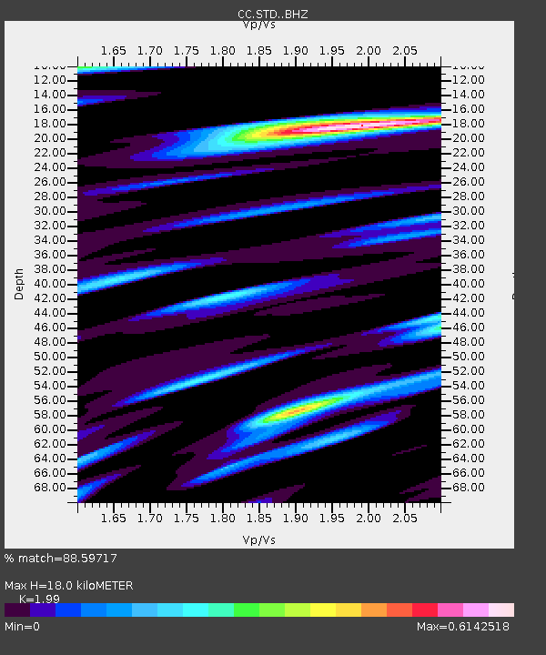
| Estimated Moho Depth: |
18.0 km |
| Estimated Crust Vp/Vs: |
1.99 |
| Assumed Crust Vp: |
6.566 km/s |
| Estimated Crust Vs: |
3.3 km/s |
| Estimated Crust Poisson's Ratio: |
0.33 |
|
| Radial Match: |
88.59717 % |
| Radial Bump: |
400 |
| Transverse Match: |
79.653534 % |
| Transverse Bump: |
400 |
| SOD ConfigId: |
20906531 |
| Insert Time: |
2020-04-08 10:21:18.784 +0000 |
| GWidth: |
2.5 |
| Max Bumps: |
400 |
| Tol: |
0.001 |
|

Signal To Noise
| Channel | StoN | STA | LTA |
| CC:STD: :BHZ:20200314T10:13:35.304997Z | 15.784161 | 2.1597996E-6 | 1.3683335E-7 |
| CC:STD: :BHN:20200314T10:13:35.304997Z | 2.656779 | 6.518144E-7 | 2.4534006E-7 |
| CC:STD: :BHE:20200314T10:13:35.304997Z | 2.9468424 | 6.868155E-7 | 2.3306828E-7 |
| Arrivals |
| Ps | 2.8 SECOND |
| PpPs | 8.0 SECOND |
| PsPs/PpSs | 11 SECOND |


