You are here: Home > Network List > CI - Caltech Regional Seismic Network Stations List
> Station MPP McPhearson Peak > Earthquake Result Viewer
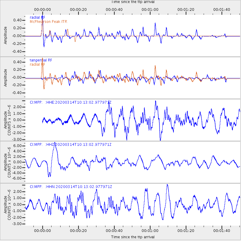
MPP McPhearson Peak - Earthquake Result Viewer
*The percent match for this event was below the threshold and hence no stack was calculated.
| Earthquake location: |
Kermadec Islands Region |
| Earthquake latitude/longitude: |
-27.4/-175.7 |
| Earthquake time(UTC): |
2020/03/14 (074) 10:01:17 GMT |
| Earthquake Depth: |
10 km |
| Earthquake Magnitude: |
6.3 Mww |
| Earthquake Catalog/Contributor: |
NEIC PDE/us |
|
| Network: |
CI Caltech Regional Seismic Network |
| Station: |
MPP McPhearson Peak |
| Lat/Lon: |
34.89 N/119.81 W |
| Elevation: |
1739 m |
|
| Distance: |
81.4 deg |
| Az: |
43.487 deg |
| Baz: |
228.086 deg |
| Ray Param: |
$rayparam |
*The percent match for this event was below the threshold and hence was not used in the summary stack. |
|
| Radial Match: |
70.612206 % |
| Radial Bump: |
400 |
| Transverse Match: |
79.42906 % |
| Transverse Bump: |
400 |
| SOD ConfigId: |
20906531 |
| Insert Time: |
2020-04-08 10:22:29.051 +0000 |
| GWidth: |
2.5 |
| Max Bumps: |
400 |
| Tol: |
0.001 |
|
Signal To Noise
| Channel | StoN | STA | LTA |
| CI:MPP: :HHZ:20200314T10:13:02.977971Z | 3.3969095 | 2.521167E-6 | 7.4219435E-7 |
| CI:MPP: :HHN:20200314T10:13:02.977971Z | 1.8390678 | 7.711119E-7 | 4.19295E-7 |
| CI:MPP: :HHE:20200314T10:13:02.977971Z | 2.924601 | 1.0912023E-6 | 3.731115E-7 |
| Arrivals |
| Ps | |
| PpPs | |
| PsPs/PpSs | |


