You are here: Home > Network List > CI - Caltech Regional Seismic Network Stations List
> Station PDM Parker Dam, Lake Havasu City, AZ, USA > Earthquake Result Viewer
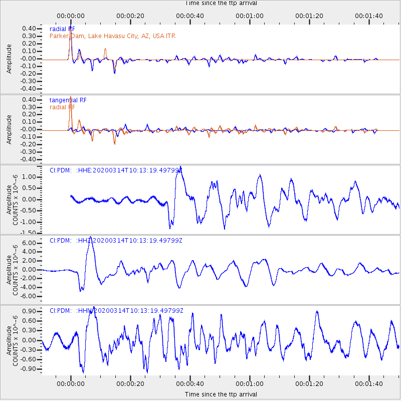
PDM Parker Dam, Lake Havasu City, AZ, USA - Earthquake Result Viewer
| Earthquake location: |
Kermadec Islands Region |
| Earthquake latitude/longitude: |
-27.4/-175.7 |
| Earthquake time(UTC): |
2020/03/14 (074) 10:01:17 GMT |
| Earthquake Depth: |
10 km |
| Earthquake Magnitude: |
6.3 Mww |
| Earthquake Catalog/Contributor: |
NEIC PDE/us |
|
| Network: |
CI Caltech Regional Seismic Network |
| Station: |
PDM Parker Dam, Lake Havasu City, AZ, USA |
| Lat/Lon: |
34.30 N/114.14 W |
| Elevation: |
144 m |
|
| Distance: |
84.6 deg |
| Az: |
46.972 deg |
| Baz: |
231.717 deg |
| Ray Param: |
0.04535366 |
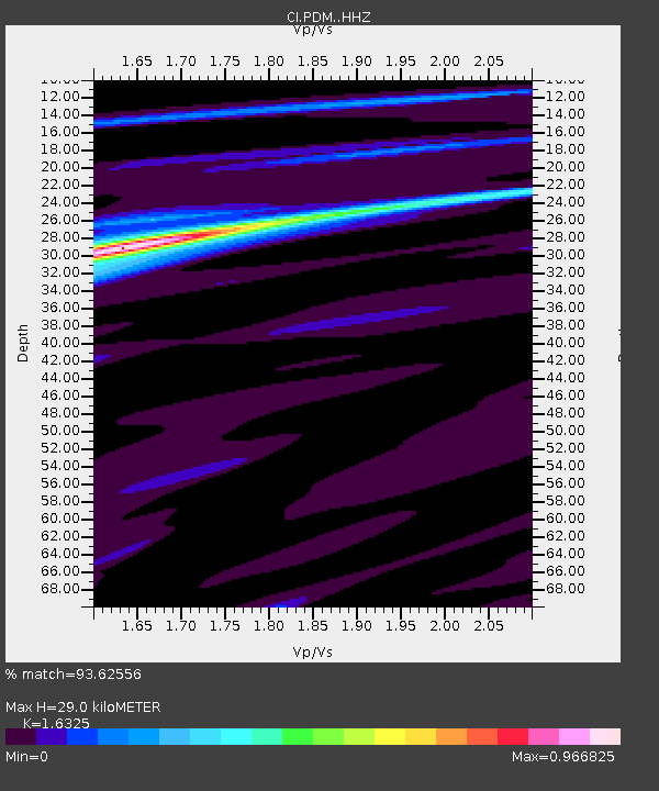
| Estimated Moho Depth: |
29.0 km |
| Estimated Crust Vp/Vs: |
1.63 |
| Assumed Crust Vp: |
6.276 km/s |
| Estimated Crust Vs: |
3.844 km/s |
| Estimated Crust Poisson's Ratio: |
0.20 |
|
| Radial Match: |
93.62556 % |
| Radial Bump: |
385 |
| Transverse Match: |
70.43885 % |
| Transverse Bump: |
400 |
| SOD ConfigId: |
20906531 |
| Insert Time: |
2020-04-08 10:22:39.461 +0000 |
| GWidth: |
2.5 |
| Max Bumps: |
400 |
| Tol: |
0.001 |
|
Signal To Noise
| Channel | StoN | STA | LTA |
| CI:PDM: :HHZ:20200314T10:13:19.49799Z | 13.432717 | 2.2822462E-6 | 1.6990205E-7 |
| CI:PDM: :HHN:20200314T10:13:19.49799Z | 3.0837057 | 4.6200287E-7 | 1.4982068E-7 |
| CI:PDM: :HHE:20200314T10:13:19.49799Z | 7.525994 | 5.938412E-7 | 7.890535E-8 |
| Arrivals |
| Ps | 3.0 SECOND |
| PpPs | 12 SECOND |
| PsPs/PpSs | 15 SECOND |


