You are here: Home > Network List > G - GEOSCOPE Stations List
> Station UNM Unam,Mexico > Earthquake Result Viewer
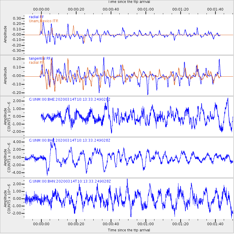
UNM Unam,Mexico - Earthquake Result Viewer
*The percent match for this event was below the threshold and hence no stack was calculated.
| Earthquake location: |
Kermadec Islands Region |
| Earthquake latitude/longitude: |
-27.4/-175.7 |
| Earthquake time(UTC): |
2020/03/14 (074) 10:01:17 GMT |
| Earthquake Depth: |
10 km |
| Earthquake Magnitude: |
6.3 Mww |
| Earthquake Catalog/Contributor: |
NEIC PDE/us |
|
| Network: |
G GEOSCOPE |
| Station: |
UNM Unam,Mexico |
| Lat/Lon: |
19.33 N/99.18 W |
| Elevation: |
2280 m |
|
| Distance: |
87.4 deg |
| Az: |
66.809 deg |
| Baz: |
239.913 deg |
| Ray Param: |
$rayparam |
*The percent match for this event was below the threshold and hence was not used in the summary stack. |
|
| Radial Match: |
70.94494 % |
| Radial Bump: |
400 |
| Transverse Match: |
65.44753 % |
| Transverse Bump: |
400 |
| SOD ConfigId: |
20906531 |
| Insert Time: |
2020-04-08 10:25:24.241 +0000 |
| GWidth: |
2.5 |
| Max Bumps: |
400 |
| Tol: |
0.001 |
|
Signal To Noise
| Channel | StoN | STA | LTA |
| G:UNM:00:BHZ:20200314T10:13:33.249028Z | 5.721228 | 1.8177127E-6 | 3.1771373E-7 |
| G:UNM:00:BHN:20200314T10:13:33.249028Z | 1.0929995 | 4.0398083E-7 | 3.6960753E-7 |
| G:UNM:00:BHE:20200314T10:13:33.249028Z | 0.995096 | 5.1522164E-7 | 5.177607E-7 |
| Arrivals |
| Ps | |
| PpPs | |
| PsPs/PpSs | |


