You are here: Home > Network List > GS - US Geological Survey Networks Stations List
> Station ASA1 ASA1 > Earthquake Result Viewer
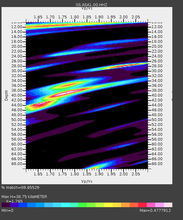
ASA1 ASA1 - Earthquake Result Viewer
| Earthquake location: |
Kermadec Islands Region |
| Earthquake latitude/longitude: |
-27.4/-175.7 |
| Earthquake time(UTC): |
2020/03/14 (074) 10:01:17 GMT |
| Earthquake Depth: |
10 km |
| Earthquake Magnitude: |
6.3 Mww |
| Earthquake Catalog/Contributor: |
NEIC PDE/us |
|
| Network: |
GS US Geological Survey Networks |
| Station: |
ASA1 ASA1 |
| Lat/Lon: |
34.95 N/106.46 W |
| Elevation: |
1829 m |
|
| Distance: |
90.1 deg |
| Az: |
50.182 deg |
| Baz: |
236.214 deg |
| Ray Param: |
0.041721147 |
| Estimated Moho Depth: |
38.75 km |
| Estimated Crust Vp/Vs: |
1.76 |
| Assumed Crust Vp: |
6.502 km/s |
| Estimated Crust Vs: |
3.684 km/s |
| Estimated Crust Poisson's Ratio: |
0.26 |
|
| Radial Match: |
89.65529 % |
| Radial Bump: |
372 |
| Transverse Match: |
74.39592 % |
| Transverse Bump: |
400 |
| SOD ConfigId: |
20906531 |
| Insert Time: |
2020-04-08 10:25:45.336 +0000 |
| GWidth: |
2.5 |
| Max Bumps: |
400 |
| Tol: |
0.001 |
|

Signal To Noise
| Channel | StoN | STA | LTA |
| GS:ASA1:00:HHZ:20200314T10:13:45.979985Z | 9.152192 | 1.4976187E-6 | 1.6363497E-7 |
| GS:ASA1:00:HH1:20200314T10:13:45.979985Z | 2.956267 | 2.596658E-7 | 8.78357E-8 |
| GS:ASA1:00:HH2:20200314T10:13:45.979985Z | 4.7547913 | 5.465731E-7 | 1.14952066E-7 |
| Arrivals |
| Ps | 4.7 SECOND |
| PpPs | 16 SECOND |
| PsPs/PpSs | 21 SECOND |


