You are here: Home > Network List > GS - US Geological Survey Networks Stations List
> Station OK051 E0350 and S34600 Roads, Ralston, OK > Earthquake Result Viewer
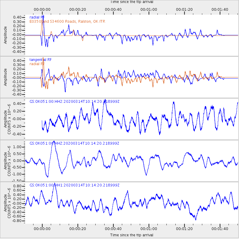
OK051 E0350 and S34600 Roads, Ralston, OK - Earthquake Result Viewer
*The percent match for this event was below the threshold and hence no stack was calculated.
| Earthquake location: |
Kermadec Islands Region |
| Earthquake latitude/longitude: |
-27.4/-175.7 |
| Earthquake time(UTC): |
2020/03/14 (074) 10:01:17 GMT |
| Earthquake Depth: |
10 km |
| Earthquake Magnitude: |
6.3 Mww |
| Earthquake Catalog/Contributor: |
NEIC PDE/us |
|
| Network: |
GS US Geological Survey Networks |
| Station: |
OK051 E0350 and S34600 Roads, Ralston, OK |
| Lat/Lon: |
36.51 N/96.84 W |
| Elevation: |
263 m |
|
| Distance: |
97.6 deg |
| Az: |
52.898 deg |
| Baz: |
241.634 deg |
| Ray Param: |
$rayparam |
*The percent match for this event was below the threshold and hence was not used in the summary stack. |
|
| Radial Match: |
57.119366 % |
| Radial Bump: |
400 |
| Transverse Match: |
57.18901 % |
| Transverse Bump: |
400 |
| SOD ConfigId: |
20906531 |
| Insert Time: |
2020-04-08 10:25:58.497 +0000 |
| GWidth: |
2.5 |
| Max Bumps: |
400 |
| Tol: |
0.001 |
|
Signal To Noise
| Channel | StoN | STA | LTA |
| GS:OK051:00:HHZ:20200314T10:14:20.218999Z | 5.7664824 | 6.5450513E-7 | 1.1350163E-7 |
| GS:OK051:00:HH1:20200314T10:14:20.218999Z | 1.4854292 | 5.9495335E-7 | 4.0052623E-7 |
| GS:OK051:00:HH2:20200314T10:14:20.218999Z | 1.8158824 | 2.48478E-7 | 1.3683594E-7 |
| Arrivals |
| Ps | |
| PpPs | |
| PsPs/PpSs | |


