You are here: Home > Network List > IE - INL Seismic Monitoring Program Stations List
> Station COMI Craters of the Moon, Idaho, USA > Earthquake Result Viewer
COMI Craters of the Moon, Idaho, USA - Earthquake Result Viewer
| Earthquake location: |
Kermadec Islands Region |
| Earthquake latitude/longitude: |
-27.4/-175.7 |
| Earthquake time(UTC): |
2020/03/14 (074) 10:01:17 GMT |
| Earthquake Depth: |
10 km |
| Earthquake Magnitude: |
6.3 Mww |
| Earthquake Catalog/Contributor: |
NEIC PDE/us |
|
| Network: |
IE INL Seismic Monitoring Program |
| Station: |
COMI Craters of the Moon, Idaho, USA |
| Lat/Lon: |
43.46 N/113.59 W |
| Elevation: |
1890 m |
|
| Distance: |
90.6 deg |
| Az: |
40.052 deg |
| Baz: |
231.774 deg |
| Ray Param: |
0.04168988 |
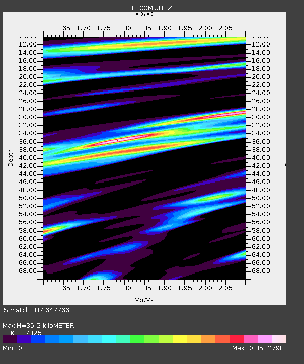
| Estimated Moho Depth: |
35.5 km |
| Estimated Crust Vp/Vs: |
1.78 |
| Assumed Crust Vp: |
6.279 km/s |
| Estimated Crust Vs: |
3.522 km/s |
| Estimated Crust Poisson's Ratio: |
0.27 |
|
| Radial Match: |
87.647766 % |
| Radial Bump: |
400 |
| Transverse Match: |
85.36871 % |
| Transverse Bump: |
400 |
| SOD ConfigId: |
20906531 |
| Insert Time: |
2020-04-08 10:26:27.403 +0000 |
| GWidth: |
2.5 |
| Max Bumps: |
400 |
| Tol: |
0.001 |
|

Signal To Noise
| Channel | StoN | STA | LTA |
| IE:COMI: :HHZ:20200314T10:13:48.328007Z | 13.754995 | 1.2370483E-6 | 8.9934474E-8 |
| IE:COMI: :HHN:20200314T10:13:48.328007Z | 5.0251055 | 4.3950166E-7 | 8.746118E-8 |
| IE:COMI: :HHE:20200314T10:13:48.328007Z | 1.4108928 | 2.4196376E-7 | 1.7149691E-7 |
| Arrivals |
| Ps | 4.5 SECOND |
| PpPs | 15 SECOND |
| PsPs/PpSs | 20 SECOND |


